
Beit Jala topographic map
Click on the map to display elevation.
Beit Jala
Beit Jala (Arabic: بيت جالا) is a Palestinian Christian town in the Bethlehem Governorate of Palestine, in the West Bank. Beit Jala is located 10 km (6.2 mi)10 km south of Jerusalem, on the western side of the Hebron road, opposite Bethlehem, at 825 meters (2,707 ft) altitude. In 2017, Beit Jala had 13,367 inhabitants according to the Palestinian Central Bureau of Statistics. About 80% of the population were Christians (mostly Greek Orthodox) and about 20% Muslims.
About this map
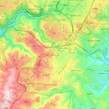
Name: Beit Jala topographic map, elevation, terrain.
Location: Beit Jala, Area A, West Bank, Palestinian Territory (31.67552 35.14737 31.75552 35.22737)
Average elevation: 2,470 ft
Minimum elevation: 1,772 ft
Maximum elevation: 3,268 ft
Other topographic maps
Click on a map to view its topography, its elevation and its terrain.
Meithalun
Palestinian Territory > Area A
The town is situated along the western edge of Marj Sanur, a valley and seasonal lake. It is the largest locality, of seven total, bordering Marj Sanur and controls the largest share of its fertile lands. It has an average elevation of 385 meters above sea level and is not elevated from its immediate…
Average elevation: 1,322 ft