
Meithalun topographic map
Click on the map to display elevation.
Meithalun
The town is situated along the western edge of Marj Sanur, a valley and seasonal lake. It is the largest locality, of seven total, bordering Marj Sanur and controls the largest share of its fertile lands. It has an average elevation of 385 meters above sea level and is not elevated from its immediate surroundings. The total land area of Meithalun is 12,495 dunams. The old core of the town consists of 18 dunams.
About this map
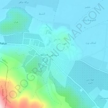
Name: Meithalun topographic map, elevation, terrain.
Location: Meithalun, Area A, West Bank, Palestinian Territory (32.33873 35.25775 32.35722 35.28243)
Average elevation: 1,322 ft
Minimum elevation: 1,138 ft
Maximum elevation: 2,415 ft
Other topographic maps
Click on a map to view its topography, its elevation and its terrain.
Beit Jala
Palestinian Territory > Area A
Beit Jala (Arabic: بيت جالا) is a Palestinian Christian town in the Bethlehem Governorate of Palestine, in the West Bank. Beit Jala is located 10 km (6.2 mi)10 km south of Jerusalem, on the western side of the Hebron road, opposite Bethlehem, at 825 meters (2,707 ft) altitude. In 2017, Beit Jala had…
Average elevation: 2,470 ft
Qabatiya
Palestinian Territory > Area A
Its entire land area is 50,547 dunams (50.5 km2; 19.5 sq mi), and its elevation is roughly 256 meters (840 feet). Qabatiya is famous for its olive groves, modern agriculture, and limestone industry.
Average elevation: 1,093 ft