
Make a donation
Gear up for your next adventure:
As an Amazon Associate, this site earns from qualifying purchases at no extra cost to you.
Riotuerto topographic map
Click on the map to display elevation.
Make a donation
Gear up for your next adventure:
As an Amazon Associate, this site earns from qualifying purchases at no extra cost to you.
About this map
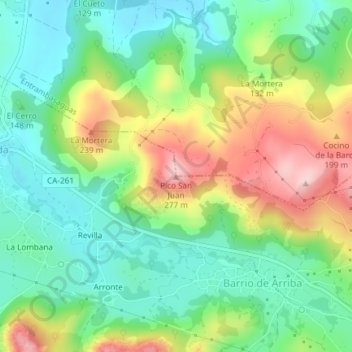
Name: Riotuerto topographic map, elevation, terrain.
Location: Riotuerto, Cantabria, 39720, Spain, Pico San Juan (43.34978 -3.68498 43.34988 -3.68488)
Average elevation: 446 ft
Minimum elevation: 177 ft
Maximum elevation: 912 ft
Make a donation
Gear up for your next adventure:
As an Amazon Associate, this site earns from qualifying purchases at no extra cost to you.
Other topographic maps
Click on a map to view its topography, its elevation and its terrain.
Make a donation
Gear up for your next adventure:
As an Amazon Associate, this site earns from qualifying purchases at no extra cost to you.
Val de San Vicente
Spain > Cantabria > Costa Occidental > Val de San Vicente
Average elevation: 318 ft