Geolocate

Santander topographic map

Click on the map to display elevation.

About this map

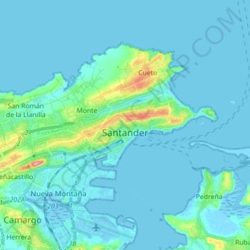
Name: Santander topographic map, elevation, terrain.

Location: Santander, Cantabria, Spain (43.43442 -3.88903 43.49488 -3.76325)

Average elevation: 33 ft

Minimum elevation: -16 ft

Maximum elevation: 318 ft

Other topographic maps

Click on a map to view its topography, its elevation and its terrain.

Garabandal

Spain > Cantabria > Rionansa

Average elevation: 2,005 ft

Villasuso

Spain > Cantabria > Cieza

Average elevation: 1,365 ft

Lavizán

Spain > Cantabria > Valderredible > Revelillas

Average elevation: 3,084 ft

San Sebastián de Garabandal

Spain > Cantabria > Rionansa

Average elevation: 2,201 ft

Calgar

Spain > Cantabria > Liérganes

Average elevation: 492 ft

Merilla

Spain > Cantabria > San Roque de Riomiera

Average elevation: 1,762 ft

Riotuerto

Spain > Cantabria

Average elevation: 446 ft

Tanarrio

Spain > Cantabria > Camaleño

Average elevation: 2,657 ft

Cave of Altamira

Spain > Cantabria > Santillana del Mar > Herrán

Average elevation: 381 ft

Quintanilla

Spain > Cantabria > Campoo-Los Valles > Campoo de Enmedio

Average elevation: 3,022 ft

Revilla

Spain > Cantabria > Riotuerto > Revilla

Average elevation: 525 ft

Gear up for your next adventure:

🕶️Glacier Sunglasses - Side shields to protect eyes from high-altitude snow glare
👟Men's Trail Runners - Lightweight footwear for fast-paced exploration and light hiking
🎒Trail Energy Bars - High‑calorie bars for hiking energy
🌡️Portable Weather Meter - Track weather conditions on the trail
👟Trail Running Shoes - Lightweight shoes for trail runners

As an Amazon Associate, this site earns from qualifying purchases at no extra cost to you.