
Make a donation
Gear up for your next adventure:
As an Amazon Associate, this site earns from qualifying purchases at no extra cost to you.
Dandara topographic map
Click on the map to display elevation.
Make a donation
Gear up for your next adventure:
As an Amazon Associate, this site earns from qualifying purchases at no extra cost to you.
About this map
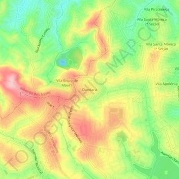
Name: Dandara topographic map, elevation, terrain.
Average elevation: 2,726 ft
Minimum elevation: 2,457 ft
Maximum elevation: 2,989 ft
Make a donation
Gear up for your next adventure:
As an Amazon Associate, this site earns from qualifying purchases at no extra cost to you.
Other topographic maps
Click on a map to view its topography, its elevation and its terrain.
JK
Brasil > Minas Gerais > Região Metropolitana de Belo Horizonte > Contagem
Average elevation: 3,028 ft
Vargem das Flores
Brasil > Minas Gerais > Região Metropolitana de Belo Horizonte > Contagem
Average elevation: 2,936 ft
Bairro da Praia
Brasil > Minas Gerais > Região Metropolitana de Belo Horizonte > Contagem
Average elevation: 2,904 ft
Nova Pampulha
Brasil > Minas Gerais > Região Metropolitana de Belo Horizonte > Contagem
Average elevation: 2,782 ft
Make a donation
Gear up for your next adventure:
As an Amazon Associate, this site earns from qualifying purchases at no extra cost to you.
Lagoa Várzea das Flores
Brasil > Minas Gerais > Região Metropolitana de Belo Horizonte > Contagem
Average elevation: 2,887 ft
Bairro da Glória
Brasil > Minas Gerais > Região Metropolitana de Belo Horizonte > Contagem
Average elevation: 3,074 ft
Arvoredo
Brasil > Minas Gerais > Região Metropolitana de Belo Horizonte > Contagem
Average elevation: 2,785 ft
CINCO II
Brasil > Minas Gerais > Região Metropolitana de Belo Horizonte > Contagem
Average elevation: 2,989 ft
Make a donation
Gear up for your next adventure:
As an Amazon Associate, this site earns from qualifying purchases at no extra cost to you.
Parque Xangri-Lá 1ª Seção
Brasil > Minas Gerais > Região Metropolitana de Belo Horizonte > Contagem
Average elevation: 2,785 ft
Nova Contagem
Brasil > Minas Gerais > Região Metropolitana de Belo Horizonte > Contagem
Average elevation: 2,976 ft
Riacho das Pedras
Brasil > Minas Gerais > Região Metropolitana de Belo Horizonte > Contagem
Average elevation: 3,130 ft
Sítio Boa Esperança
Brasil > Minas Gerais > Região Metropolitana de Belo Horizonte > Contagem
Average elevation: 2,799 ft
Make a donation
Gear up for your next adventure:
As an Amazon Associate, this site earns from qualifying purchases at no extra cost to you.
Vale das Amendoeiras
Brasil > Minas Gerais > Região Metropolitana de Belo Horizonte > Contagem
Average elevation: 2,805 ft
Morada Nova
Brasil > Minas Gerais > Região Metropolitana de Belo Horizonte > Contagem
Average elevation: 2,969 ft
Chácara Califórnia
Brasil > Minas Gerais > Região Metropolitana de Belo Horizonte > Contagem
Average elevation: 2,927 ft
Canadá
Brasil > Minas Gerais > Região Metropolitana de Belo Horizonte > Contagem
Average elevation: 3,048 ft
Make a donation
Gear up for your next adventure:
As an Amazon Associate, this site earns from qualifying purchases at no extra cost to you.
Centro
Brasil > Minas Gerais > Região Metropolitana de Belo Horizonte > Contagem
Average elevation: 2,999 ft
Tijuca
Brasil > Minas Gerais > Região Metropolitana de Belo Horizonte > Contagem
Average elevation: 2,756 ft
Cidade Industrial Coronel Juventino Dias
Brasil > Minas Gerais > Região Metropolitana de Belo Horizonte > Contagem
Average elevation: 3,035 ft
Parque Industrial
Brasil > Minas Gerais > Região Metropolitana de Belo Horizonte > Contagem
Average elevation: 3,091 ft
Make a donation
Gear up for your next adventure:
As an Amazon Associate, this site earns from qualifying purchases at no extra cost to you.
Kennedy
Brasil > Minas Gerais > Região Metropolitana de Belo Horizonte > Contagem
Average elevation: 2,812 ft
Fazenda Água Branca
Brasil > Minas Gerais > Região Metropolitana de Belo Horizonte > Contagem
Average elevation: 3,041 ft
Nacional
Brasil > Minas Gerais > Região Metropolitana de Belo Horizonte > Contagem
Average elevation: 2,792 ft
Ressaca
Brasil > Minas Gerais > Região Metropolitana de Belo Horizonte > Contagem
Average elevation: 2,835 ft
Make a donation
Gear up for your next adventure:
As an Amazon Associate, this site earns from qualifying purchases at no extra cost to you.
Vila Beneves
Brasil > Minas Gerais > Região Metropolitana de Belo Horizonte > Contagem
Average elevation: 2,943 ft
Riacho das Pedras
Brasil > Minas Gerais > Região Metropolitana de Belo Horizonte > Contagem
Average elevation: 3,130 ft