
Vogel topographic map
Click on the map to display elevation.
About this map
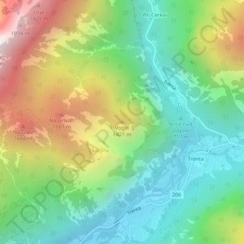
Name: Vogel topographic map, elevation, terrain.
Location: Vogel, Bovec, Slovenia (46.38485 13.73999 46.38495 13.74009)
Average elevation: 3,520 ft
Minimum elevation: 1,886 ft
Maximum elevation: 6,414 ft
Other topographic maps
Click on a map to view its topography, its elevation and its terrain.
Soča
An Alpine river in character, its source lies in the Trenta Valley in the Julian Alps in northwestern Slovenia, at an elevation of 876 metres (2,874 ft). The river runs past the towns of Bovec, Kobarid, Tolmin, Kanal ob Soči, Nova Gorica (where it is crossed by the Solkan Bridge), and Gorizia, entering the…
Average elevation: 2,041 ft