
Make a donation
Gear up for your next adventure:
As an Amazon Associate, this site earns from qualifying purchases at no extra cost to you.
Mechanicsburg topographic map
Click on the map to display elevation.
Make a donation
Gear up for your next adventure:
As an Amazon Associate, this site earns from qualifying purchases at no extra cost to you.
About this map
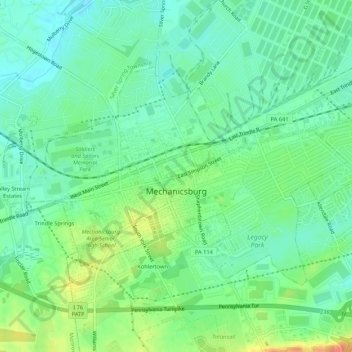
Name: Mechanicsburg topographic map, elevation, terrain.
Average elevation: 443 ft
Minimum elevation: 390 ft
Maximum elevation: 538 ft
Cumberland County trails, hiking, mountain biking, running and outdoor activities
Make a donation
Gear up for your next adventure:
As an Amazon Associate, this site earns from qualifying purchases at no extra cost to you.
Other topographic maps
Click on a map to view its topography, its elevation and its terrain.
Carlisle Springs
United States > Pennsylvania > Cumberland County > Middlesex Township
Average elevation: 597 ft
Pine Grove Furnace
United States > Pennsylvania > Cumberland County > Cooke Township
Average elevation: 1,089 ft
Mount Zion
United States > Pennsylvania > Cumberland County > South Middleton Township
Average elevation: 587 ft
Carlisle Springs
United States > Pennsylvania > Cumberland County > Middlesex Township
Average elevation: 597 ft
Make a donation
Gear up for your next adventure:
As an Amazon Associate, this site earns from qualifying purchases at no extra cost to you.
Chestnut Crossroads
United States > Pennsylvania > Cumberland County > Southampton Township
Average elevation: 840 ft
Green Spring
United States > Pennsylvania > Cumberland County > North Newton Township
Average elevation: 571 ft
Treemont
United States > Pennsylvania > Cumberland County > East Pennsboro Township
Average elevation: 531 ft
Caprivi
United States > Pennsylvania > Cumberland County > North Middleton Township
Average elevation: 512 ft
Make a donation
Gear up for your next adventure:
As an Amazon Associate, this site earns from qualifying purchases at no extra cost to you.
Springville
United States > Pennsylvania > Cumberland County > South Middleton Township
Average elevation: 531 ft
Liebys Trailer Park
United States > Pennsylvania > Cumberland County > Liebys Trailer Park
Average elevation: 453 ft
Drexel Hills
United States > Pennsylvania > Cumberland County > New Cumberland
Average elevation: 364 ft