
Make a donation
Gear up for your next adventure:
As an Amazon Associate, this site earns from qualifying purchases at no extra cost to you.
Lassen Peak topographic map
Click on the map to display elevation.
Make a donation
Gear up for your next adventure:
As an Amazon Associate, this site earns from qualifying purchases at no extra cost to you.
Lassen Peak
Lassen Peak (/ˈlæsən/ LASS-ən), commonly referred to as Mount Lassen, is a 10,457 ft (3,187 m) lava dome volcano in Lassen Volcanic National Park in Northern California. Located in the Shasta Cascade region above the northern Sacramento Valley, it is the southernmost active volcano in the Cascade Range of the Western United States, and part of the Cascade Volcanic Arc stretching from southwestern British Columbia to Northern California. It supports many flora and fauna among its diverse habitats, which reach high elevations and are subject to frequent snowfall.
Make a donation
Gear up for your next adventure:
As an Amazon Associate, this site earns from qualifying purchases at no extra cost to you.
About this map
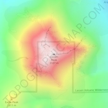
Name: Lassen Peak topographic map, elevation, terrain.
Location: Lassen Peak, Shasta County, California, United States (40.48808 -121.50497 40.48818 -121.50487)
Average elevation: 8,822 ft
Minimum elevation: 7,582 ft
Maximum elevation: 10,381 ft
Shasta County trails, hiking, mountain biking, running and outdoor activities
Make a donation
Gear up for your next adventure:
As an Amazon Associate, this site earns from qualifying purchases at no extra cost to you.
Other topographic maps
Click on a map to view its topography, its elevation and its terrain.
Redding
United States > California > Shasta County
The elevation in Redding is 495 feet (151 meters) on average, whereas anywhere to the north, east, or west of downtown ranges between 550 feet (170 m) and 800 feet (240 m) feet. Southern portions range between 400 feet (120 m) and 500 feet (150 m).
Average elevation: 787 ft
Redding
United States > California > Shasta County
The elevation in Redding is 495 feet (151 meters) on average, whereas anywhere to the north, east, or west of downtown ranges between 550 feet (170 m) and 800 feet (240 m) feet. Southern portions range between 400 feet (120 m) and 500 feet (150 m).
Average elevation: 791 ft
Make a donation
Gear up for your next adventure:
As an Amazon Associate, this site earns from qualifying purchases at no extra cost to you.
Make a donation
Gear up for your next adventure:
As an Amazon Associate, this site earns from qualifying purchases at no extra cost to you.
Whiskeytown-Shasta-Trinity National Recreation Area - Shasta Unit
United States > California > Shasta County
Average elevation: 2,008 ft
Lassen Volcanic National Park
United States > California > Shasta County
According to the Köppen climate classification system, Lassen Volcanic National Park has a Mediterranean-influenced warm-summer Humid continental climate (Dsb). According to the United States Department of Agriculture, the Plant Hardiness zone at Kohm Yah-mah-nee Visitor Center at 6,736 ft (2,053 m) elevation…
Average elevation: 6,470 ft
Make a donation
Gear up for your next adventure:
As an Amazon Associate, this site earns from qualifying purchases at no extra cost to you.
Lassen Volcanic National Park
United States > California > Shasta County
According to the Köppen climate classification system, Lassen Volcanic National Park has a Mediterranean-influenced warm-summer Humid continental climate (Dsb). According to the United States Department of Agriculture, the Plant Hardiness zone at Kohm Yah-mah-nee Visitor Center at 6,736 ft (2,053 m) elevation…
Average elevation: 6,470 ft
Redding
United States > California > Shasta County
The elevation in Redding is 495 feet (151 meters) on average, whereas anywhere to the north, east, or west of downtown ranges between 550 and 800 feet (170 and 240 m). Southern portions range between 400 and 500 feet (120 and 150 m).
Average elevation: 791 ft
Make a donation
Gear up for your next adventure:
As an Amazon Associate, this site earns from qualifying purchases at no extra cost to you.
Make a donation
Gear up for your next adventure:
As an Amazon Associate, this site earns from qualifying purchases at no extra cost to you.
Lassen Volcanic National Park
United States > California > Shasta County
According to the Köppen climate classification system, Lassen Volcanic National Park has a Mediterranean-influenced warm-summer Humid continental climate (Dsb). According to the United States Department of Agriculture, the Plant Hardiness zone at Kohm Yah-mah-nee Visitor Center at 6,736 ft (2,053 m) elevation…
Average elevation: 6,470 ft
Palo Cedro
United States > California > Shasta County
Palo Cedro is located at 40°33′4″N 122°14′3″W / 40.55111°N 122.23417°W / 40.55111; -122.23417 (40.551091, −122.234255) at an elevation of 465 ft (143 m) above sea level.
Average elevation: 515 ft
Make a donation
Gear up for your next adventure:
As an Amazon Associate, this site earns from qualifying purchases at no extra cost to you.
Palo Cedro
United States > California > Shasta County
Palo Cedro is located at 40°33′4″N 122°14′3″W / 40.55111°N 122.23417°W / 40.55111; -122.23417 (40.551091, −122.234255) at an elevation of 465 ft (143 m) above sea level.
Average elevation: 515 ft
Whiskeytown-Shasta-Trinity National Recreation Area - Shasta Unit
United States > California > Shasta County
Average elevation: 2,008 ft