
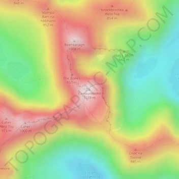
Carrauntoohil topographic map
Interactive map
Click on the map to display elevation.
About this map
Name: Carrauntoohil topographic map, elevation, terrain.
Average elevation: 2,113 ft
Minimum elevation: 978 ft
Maximum elevation: 3,337 ft
Carrauntoohil is the highest mountain in Ireland on all classification scales. It is the 133rd-highest mountain, and 4th most prominent mountain, in Britain and Ireland, on the Simms classification. Carrauntoohil is regarded by the Scottish Mountaineering Club (SMC) as one of 34 Furths, which are defined as mountains above 3,000 feet (910 m) in elevation and meeting the SMC criteria for a Munro (i.e. "sufficient separation"), and which are outside (or furth), of Scotland; this is why Carrauntoohil is also referred to as one of the thirteen Irish Munros.
Other topographic maps
Click on a map to view its topography, its elevation and its terrain.
Great Skellig
Great Skellig, Kenmare Municipal District, County Kerry, Munster, Ireland
Average elevation: 3 ft
Killarney
Killarney, Killarney Municipal District, County Kerry, Munster, Ireland
Average elevation: 187 ft
Brick
Brick, Lixnaw ED, Listowel Municipal District, County Kerry, Munster, Ireland
Average elevation: 16 ft
Caher
Caher, Kenmare Municipal District, County Kerry, Munster, V93 A8N1, Ireland
Average elevation: 2,024 ft
Kenmare Municipal District
Kenmare Municipal District, County Kerry, Munster, Ireland
Average elevation: 322 ft
Tralee
Ireland > County Kerry > Tralee
Tralee, Tralee Municipal District, County Kerry, Munster, Ireland
Average elevation: 66 ft
Dingle
Dingle, Kenmare Municipal District, County Kerry, Munster, Ireland
Average elevation: 397 ft
Brick
Brick, Lixnaw ED, Listowel Municipal District, County Kerry, Munster, Ireland
Average elevation: 16 ft