Geolocate

Mayer topographic map

Click on the map to display elevation.

About this map

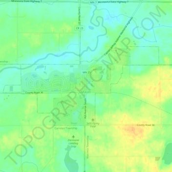
Name: Mayer topographic map, elevation, terrain.

Location: Mayer, Carver County, Minnesota, 55360, United States (44.87722 -93.91480 44.89536 -93.85906)

Average elevation: 971 ft

Minimum elevation: 925 ft

Maximum elevation: 1,027 ft

Carver County trails, hiking, mountain biking, running and outdoor activities

Other topographic maps

Click on a map to view its topography, its elevation and its terrain.

Augusta

United States > Minnesota > Carver County

Average elevation: 965 ft

Assumption

United States > Minnesota > Carver County

Average elevation: 984 ft

Young America

United States > Minnesota > Carver County

Average elevation: 991 ft

Carver Beach

United States > Minnesota > Carver County > Chanhassen

Average elevation: 951 ft

Dahlgren

United States > Minnesota > Carver County

Average elevation: 945 ft

Hollywood

United States > Minnesota > Carver County

Average elevation: 981 ft

Gear up for your next adventure:

🚪Portable Camp Chair - Foldable chair for comfort at camp
🧭GPS Watch Accessories - Bands and chargers for GPS watches
🔊Portable Camp Speaker - Music and alerts at camp
🧭Pro Hiking Compasses - High-accuracy liquid-filled compasses for topographic orientation
🧣Merino Neck Gaiters - Multi-functional headwear for wind and sun protection

As an Amazon Associate, this site earns from qualifying purchases at no extra cost to you.