
Make a donation
Gear up for your next adventure:
As an Amazon Associate, this site earns from qualifying purchases at no extra cost to you.
Sabugal topographic map
Click on the map to display elevation.
Make a donation
Gear up for your next adventure:
As an Amazon Associate, this site earns from qualifying purchases at no extra cost to you.
About this map
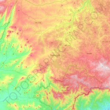
Name: Sabugal topographic map, elevation, terrain.
Average elevation: 2,444 ft
Minimum elevation: 1,263 ft
Maximum elevation: 3,743 ft
Make a donation
Gear up for your next adventure:
As an Amazon Associate, this site earns from qualifying purchases at no extra cost to you.
Other topographic maps
Click on a map to view its topography, its elevation and its terrain.
Make a donation
Gear up for your next adventure:
As an Amazon Associate, this site earns from qualifying purchases at no extra cost to you.
Figueiró da Granja
Aldeia situada nas proximidades da margem direita do rio Mondego, a cerca de 6 quilómetros da sede do município - Fornos de Algodres - e tendo como ponto mais alto o alto de Santiago, a 614 metros de altitude.
Average elevation: 1,555 ft
Make a donation
Gear up for your next adventure:
As an Amazon Associate, this site earns from qualifying purchases at no extra cost to you.
Almeida
O município atinge altitude próxima aos 765m na área do antigo Castelo, dentro da Fortaleza de Almeida. Esta posição permite a visualização - impedida apenas por condições climáticas - da Serra da Marofa (noroeste) e da Serra da Estrela (sudoeste). Para o lado leste, pode-se avistar a Serra de…
Average elevation: 2,375 ft
Celorico da Beira
O centro de Celorico da Beira tem uma área de 2,66km2. A altitude tem uma variação de 439m na parte mais baixa (Variante – Rotunda para Ratoeira-Celorico-Trancoso) na freguesia de Santa Maria, e 551m (no castelo) na fronteira da mesma freguesia com São Pedro. A altitude média da Vila é 513m. Celorico…
Average elevation: 2,047 ft
Fornos de Algodres
Como deputado esteve ligado à reorganização administrativa de 1836, devendo-se certamente à sua influência a elevação de Fornos de Algodres a sede de concelho. Depois, em 1838, Costa Cabral foi chamado a desempenhar as funções de Ministro da Justiça e mais tarde, em 1842, já com novo governo…
Average elevation: 1,850 ft
Gouveia
Gouveia é uma cidade portuguesa do distrito da Guarda, situada na província da Beira Alta, região do Centro (Região das Beiras) e sub-região das Beiras e Serra da Estrela. Situa-se na encosta noroeste do maior sistema montanhoso português continental, a Serra da Estrela, a cerca de 700m de altitude.
Average elevation: 2,320 ft
Make a donation
Gear up for your next adventure:
As an Amazon Associate, this site earns from qualifying purchases at no extra cost to you.
Manteigas
Um dos pratos típicos de Manteigas designa-se por "Feijoca de Manteigas", sendo composto por feijoca guisada com carnes de porco. A feijoca de Manteigas, variedade de feijão graúdo que é cultivada em altitude e regada pelas águas da bacia do Zêzere, tem um sabor único, de textura aveludada.
Average elevation: 3,891 ft
Mêda
O município é delimitado a norte pelo município de Vila Nova de Foz Côa, a este também por Vila Nova de Foz Côa e por Pinhel, a oeste pelo município de Penedono e a sul pelo município de Trancoso. Está situado a cerca de 670 metros de altitude, num planalto entre a antiga Beira Alta e o Alto Douro,…
Average elevation: 1,952 ft
Seia
O município é limitado a norte pelos municípios de Nelas e Mangualde, a nordeste por Gouveia, a leste por Manteigas, a sueste pela Covilhã, a sudoeste por Arganil e a oeste por Oliveira do Hospital. Neste município está localizado o ponto mais alto de Portugal continental, a Torre, na Serra da Estrela,…
Average elevation: 2,474 ft
Make a donation
Gear up for your next adventure:
As an Amazon Associate, this site earns from qualifying purchases at no extra cost to you.
Trancoso
Trancoso é uma cidade portuguesa pertencente ao distrito da Guarda, na província da Beira Alta, região do Centro (Região das Beiras) e sub-região da Beira Interior Norte, com cerca de 3 420 habitantes (2011), situada num planalto em que o ponto mais alto tem 939 m de altitude.
Average elevation: 2,201 ft
Make a donation
Gear up for your next adventure:
As an Amazon Associate, this site earns from qualifying purchases at no extra cost to you.
Alvoco da Serra
Situada no coração do Parque Natural da Serra da Estrela, a 684 metros de altitude. É a povoação topograficamente mais próxima da Torre.
Average elevation: 3,264 ft
Sabugueiro
O Sabugueiro é por vezes denominada a "aldeia mais alta de Portugal", no entanto esta designação não é correta, uma vez que existem aldeias que atingem altitudes superiores. Segundo a carta topográfica 1:25000 do CIGeoE, e tomando como critério a cota altimétrica do edifício que se encontra na parte…
Average elevation: 4,721 ft
Make a donation
Gear up for your next adventure:
As an Amazon Associate, this site earns from qualifying purchases at no extra cost to you.
Make a donation
Gear up for your next adventure:
As an Amazon Associate, this site earns from qualifying purchases at no extra cost to you.
Make a donation
Gear up for your next adventure:
As an Amazon Associate, this site earns from qualifying purchases at no extra cost to you.
Make a donation
Gear up for your next adventure:
As an Amazon Associate, this site earns from qualifying purchases at no extra cost to you.
Juncais
Portugal > Guarda > Juncais, Vila Ruiva e Vila Soeiro do Chão > Juncais
Average elevation: 1,368 ft
Barragem
Portugal > Guarda > Aldeia da Ribeira, Vilar Maior e Badamalos > Batocas
Average elevation: 2,707 ft
Make a donation
Gear up for your next adventure:
As an Amazon Associate, this site earns from qualifying purchases at no extra cost to you.
Aguiar da Beira
Com sede na vila homónima de Aguiar da Beira que se ergue a 781 m de altitude, este município tem 206,75 km² de área e 5 231 habitantes (2021), subdividido em 10 freguesias. O Município de Aguiar da Beira é limitado a norte pelo município de Sernancelhe, a leste por Trancoso, a sudeste por Fornos de…
Average elevation: 2,238 ft
Make a donation
Gear up for your next adventure:
As an Amazon Associate, this site earns from qualifying purchases at no extra cost to you.
Make a donation
Gear up for your next adventure:
As an Amazon Associate, this site earns from qualifying purchases at no extra cost to you.
Make a donation
Gear up for your next adventure:
As an Amazon Associate, this site earns from qualifying purchases at no extra cost to you.
Folgosinho
Foi vila e sede de concelho entre 1187 e 1836. Era constituído apenas pela freguesia da sede. Localiza-se na vertente Noroeste da Serra da Estrela, atingindo os 930 metros de altitude.
Average elevation: 3,107 ft
Make a donation
Gear up for your next adventure:
As an Amazon Associate, this site earns from qualifying purchases at no extra cost to you.
Pai Penela
Portugal > Guarda > Vale Flor, Carvalhal e Pai Penela > Casa do Povo e Sede da Junta de Freguesia
Average elevation: 2,339 ft
Make a donation
Gear up for your next adventure:
As an Amazon Associate, this site earns from qualifying purchases at no extra cost to you.
Vila Nova de Foz Côa
Os temas abordados são diversos, resultando de uma dinâmica de trabalho que procura cruzar fatores exteriores, como topografia e acessibilidades, e fatores de conteúdo programático. O desafio de fundir estes fatores torna-se explicito no conceito da intervenção conceber um museu enquanto integração na paisagem.
Average elevation: 1,509 ft
Make a donation
Gear up for your next adventure:
As an Amazon Associate, this site earns from qualifying purchases at no extra cost to you.
Make a donation
Gear up for your next adventure:
As an Amazon Associate, this site earns from qualifying purchases at no extra cost to you.
Cerdeira
A freguesia tem uma extensão máxima de 9.594 m (NW-SE) e uma largura máxima de 3.780 m (SW-NE), entre a ribeira das Cabras, a norte, e o rio Côa, a sul. A meio, é atravessada pelo vale do rio Noéme (E-W), a uma altitude média de 725 m. Ao longo do vale, segue a linha ferroviária da Beira Alta.…
Average elevation: 2,530 ft
Make a donation
Gear up for your next adventure:
As an Amazon Associate, this site earns from qualifying purchases at no extra cost to you.
Make a donation
Gear up for your next adventure:
As an Amazon Associate, this site earns from qualifying purchases at no extra cost to you.
Linha de cumeada da serra da Marofa
Portugal > Guarda > Figueira de Castelo Rodrigo
Average elevation: 2,001 ft
Figueira de Castelo Rodrigo
Muito da singularidade geográfico-natural do município de Figueira de Castelo Rodrigo deve-se ao seu enquadramento físico que em termos morfológicos se caracteriza por um profundo dualismo: Toda a área envolvente é composta pela superfície da Meseta que prolonga, no sector Sul do município, o Planalto…
Average elevation: 1,762 ft
Guarda
Guarda é uma cidade portuguesa com 1 056 metros de altitude máxima, sendo a mais alta cidade do país. Com 26 446 habitantes (2021) no seu perímetro urbano, é a capital do Distrito da Guarda, estando situada na região estatística do Centro e sub-região das Beiras e Serra da Estrela.
Average elevation: 2,434 ft
Make a donation
Gear up for your next adventure:
As an Amazon Associate, this site earns from qualifying purchases at no extra cost to you.
Make a donation
Gear up for your next adventure:
As an Amazon Associate, this site earns from qualifying purchases at no extra cost to you.
Aldeia da Ribeira
Portugal > Guarda > Aldeia da Ribeira, Vilar Maior e Badamalos
Average elevation: 2,677 ft
Make a donation
Gear up for your next adventure:
As an Amazon Associate, this site earns from qualifying purchases at no extra cost to you.
Make a donation
Gear up for your next adventure:
As an Amazon Associate, this site earns from qualifying purchases at no extra cost to you.
Make a donation
Gear up for your next adventure:
As an Amazon Associate, this site earns from qualifying purchases at no extra cost to you.
Make a donation
Gear up for your next adventure:
As an Amazon Associate, this site earns from qualifying purchases at no extra cost to you.