Geolocate

Emerald Isle topographic map

Click on the map to display elevation.

About this map

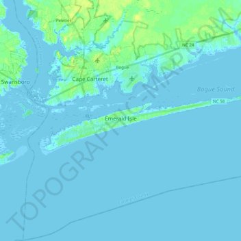
Name: Emerald Isle topographic map, elevation, terrain.

Location: Emerald Isle, Carteret County, North Carolina, 28594, United States (34.64340 -77.10476 34.68434 -76.91038)

Average elevation: 7 ft

Minimum elevation: -10 ft

Maximum elevation: 56 ft

Carteret County trails, hiking, mountain biking, running and outdoor activities

Other topographic maps

Click on a map to view its topography, its elevation and its terrain.

Stacy

United States > North Carolina > Carteret County

Average elevation: 3 ft

Tusk

United States > North Carolina > Carteret County

Average elevation: 7 ft

Smyrna

United States > North Carolina > Carteret County

Average elevation: 7 ft

Stella

United States > North Carolina > Carteret County

Average elevation: 10 ft

Bettie

United States > North Carolina > Carteret County

Average elevation: 3 ft

Harlowe

United States > North Carolina > Carteret County

Average elevation: 20 ft

Gear up for your next adventure:

🪓Survival Multi‑Tool - Versatile tool for camp and trail tasks
Camping Coffee Makers - Enjoy premium coffee at the summit or campsite
🔋Rechargeable Batteries - Power up your outdoor devices
🚁Photography Drones - Capture stunning aerial views of landforms and topography
🔦Powerful Headlamps - Ultra-bright hands-free lighting for night navigation

As an Amazon Associate, this site earns from qualifying purchases at no extra cost to you.