
Bever topographic map
Interactive map
Click on the map to display elevation.
About this map
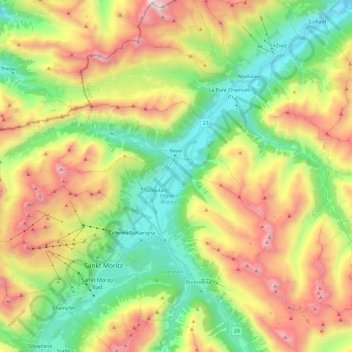
Name: Bever topographic map, elevation, terrain.
Location: Bever, Maloja, Graubünden, 7502, Schweiz (46.50459 9.69347 46.57502 9.93385)
Average elevation: 7,644 ft
Minimum elevation: 5,364 ft
Maximum elevation: 11,125 ft
Other topographic maps
Click on a map to view its topography, its elevation and its terrain.
Castasengen
Schweiz > Graubünden > Maloja
Das Dorf liegt auf einer Höhe von 690 m ü. M. an der Grenze gegen Italien, an der Strasse Samedan-Maloja-Chiavenna, am rechten Ufer der Maira und an der Einmündung des Lovero und des Baches des Val Casnaggina in diese; 9,7 km östlich von Chiavenna. Castasegna liegt unmittelbar an der Grenze zwischen…
Average elevation: 4,029 ft