Geolocate

Zena topographic map

Click on the map to display elevation.

About this map

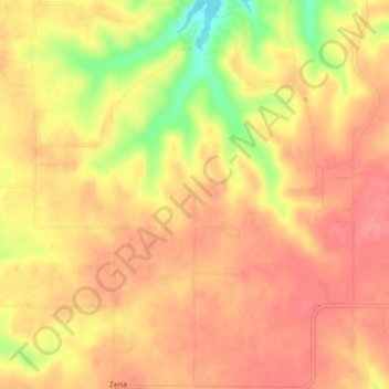
Name: Zena topographic map, elevation, terrain.

Location: Zena, Delaware County, Oklahoma, United States (36.49577 -94.86296 36.53073 -94.82707)

Average elevation: 915 ft

Minimum elevation: 735 ft

Maximum elevation: 994 ft

Delaware County trails, hiking, mountain biking, running and outdoor activities

Other topographic maps

Click on a map to view its topography, its elevation and its terrain.

Chloeta

United States > Oklahoma > Delaware County

Average elevation: 863 ft

Eucha

United States > Oklahoma > Delaware County

Average elevation: 1,024 ft

Kenwood

United States > Oklahoma > Delaware County

Average elevation: 866 ft

Gear up for your next adventure:

📚Navigation Handbooks - Master the art of reading topographic maps and using a compass
🪓Survival Multi‑Tool - Versatile tool for camp and trail tasks
🪶Trail Camera - Capture wildlife on your hikes
🧣Hiking Neck Gaiter - Multi‑use neck protection for outdoor weather
🌡️Portable Weather Meter - Track weather conditions on the trail

As an Amazon Associate, this site earns from qualifying purchases at no extra cost to you.