
Make a donation
Gear up for your next adventure:
As an Amazon Associate, this site earns from qualifying purchases at no extra cost to you.
Stein (AR) topographic map
Click on the map to display elevation.
Make a donation
Gear up for your next adventure:
As an Amazon Associate, this site earns from qualifying purchases at no extra cost to you.
About this map
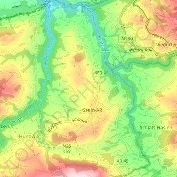
Name: Stein (AR) topographic map, elevation, terrain.
Average elevation: 2,523 ft
Minimum elevation: 1,955 ft
Maximum elevation: 3,261 ft
Make a donation
Gear up for your next adventure:
As an Amazon Associate, this site earns from qualifying purchases at no extra cost to you.
Other topographic maps
Click on a map to view its topography, its elevation and its terrain.
Hundwil
Suisse > Appenzell Rhodes-Extérieures > Hinterland > Hundwil > Hundwil
La commune de Hundwil est située au pied du Säntis. Son altitude est comprise entre 655 mètres, au bord de la rivière Urnäsch, et 2 501 mètres, au sommet du Säntis. Le col de la Schwägalp, station de départ du téléphérique du Säntis, se trouve également sur le territoire communal.
Average elevation: 2,726 ft