
Make a donation
Gear up for your next adventure:
As an Amazon Associate, this site earns from qualifying purchases at no extra cost to you.
Chorvátsky Grob topographic map
Click on the map to display elevation.
Make a donation
Gear up for your next adventure:
As an Amazon Associate, this site earns from qualifying purchases at no extra cost to you.
About this map
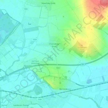
Name: Chorvátsky Grob topographic map, elevation, terrain.
Average elevation: 456 ft
Minimum elevation: 407 ft
Maximum elevation: 643 ft
Make a donation
Gear up for your next adventure:
As an Amazon Associate, this site earns from qualifying purchases at no extra cost to you.
Other topographic maps
Click on a map to view its topography, its elevation and its terrain.
Veľký Biel
Slovakia > Region of Bratislava > District of Senec
The municipality lies at an altitude of 131 metres and covers an area of 10.161 km². It has a population of 2303 people.
Average elevation: 427 ft
Chorvátsky Grob
Slovakia > Region of Bratislava > District of Senec > Chorvátsky Grob > Chorvátsky Grob
Average elevation: 463 ft