Geolocate

Greverud topographic map

Click on the map to display elevation.

About this map
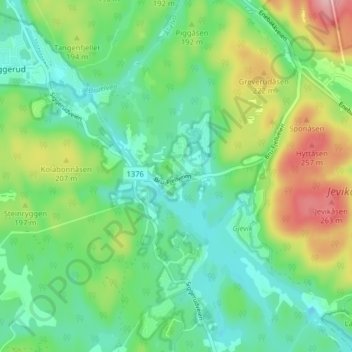
Name: Greverud topographic map, elevation, terrain.

Location: Greverud, Nordre Follo, Viken, 1404, Norway (59.75870 10.89984 59.79870 10.93984)

Average elevation: 551 ft

Minimum elevation: 390 ft

Maximum elevation: 896 ft

Other topographic maps

Click on a map to view its topography, its elevation and its terrain.

Utøya

Norway > Viken

Average elevation: 292 ft

Ås

Norway > Viken

Average elevation: 322 ft

Konnerud

Norway > Viken

Average elevation: 810 ft

Lier

Norway > Viken

Average elevation: 928 ft

Storøyungen

Norway > Viken

Average elevation: 1,161 ft

Svelvik

Norway > Viken

Average elevation: 433 ft

Aspern

Norway > Viken

Average elevation: 430 ft

Rakkestad

Norway > Viken

Average elevation: 456 ft

Rauer

Norway > Viken

Average elevation: 7 ft

Ullensaker

Norway > Viken

Average elevation: 594 ft

Øvre Eiker

Norway > Viken

Average elevation: 1,007 ft

Gear up for your next adventure:

🎒Gear Packing Cubes - Organize your backpack efficiently
🧭Orienteering Set - Complete compass and map reading kit
🎒Outdoor Daypacks - Lightweight backpacks designed for carrying maps and essential gear
🗃️Trail First Aid Kit - Essential kit for outdoor injuries and emergencies
🔭Compact Binoculars - HD vision for scouting terrain and identifying distant landmarks

As an Amazon Associate, this site earns from qualifying purchases at no extra cost to you.