Geolocate

Carytown topographic map

Click on the map to display elevation.

About this map

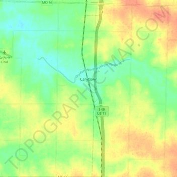
Name: Carytown topographic map, elevation, terrain.

Location: Carytown, Jasper County, Missouri, United States (37.22740 -94.36388 37.29742 -94.30372)

Average elevation: 965 ft

Minimum elevation: 896 ft

Maximum elevation: 1,037 ft

Jasper County trails, hiking, mountain biking, running and outdoor activities

Other topographic maps

Click on a map to view its topography, its elevation and its terrain.

Joplin

United States > Missouri > Jasper County > Joplin

Average elevation: 984 ft

Belle Center

United States > Missouri > Jasper County

Average elevation: 961 ft

Atlas

United States > Missouri > Jasper County

Average elevation: 1,037 ft

Oakland Park

United States > Missouri > Jasper County > Webb City

Average elevation: 1,020 ft

Center Creek

United States > Missouri > Jasper County > Oronogo

Average elevation: 981 ft

Gear up for your next adventure:

🦺Reflective Outdoor Gear - Safety gear for low‑light conditions
👓Polarized Sunglasses - Outdoor sunglasses for glare reduction
🥇GPS Hiking Watch - Multi‑sport GPS watch with navigation and trail tracking
🧣Hiking Neck Gaiter - Multi‑use neck protection for outdoor weather
🧤Hiking Gloves - Protective gloves for rugged trails

As an Amazon Associate, this site earns from qualifying purchases at no extra cost to you.