
Mount Olympus topographic map
Interactive map
Click on the map to display elevation.
About this map
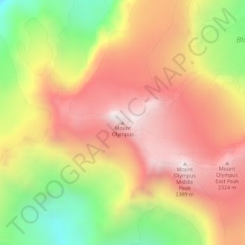
Name: Mount Olympus topographic map, elevation, terrain.
Location: Mount Olympus, Jefferson County, Washington, United States (47.80117 -123.71096 47.80127 -123.71086)
Average elevation: 6,345 ft
Minimum elevation: 4,386 ft
Maximum elevation: 7,861 ft
With notable local relief, Mount Olympus ascends over 2,100 m (6,900 ft) from the 293 m (961 ft) elevation confluence of the Hoh River with Glacier Creek in only 8.8 km (5.5 mi). Mount Olympus has 2,386 m (7,828 ft) of prominence, ranking 5th in the state of Washington.
Other topographic maps
Click on a map to view its topography, its elevation and its terrain.
Port Townsend
United States > Washington > Jefferson County
Port Townsend, Jefferson County, Washington, United States
Average elevation: 62 ft
Olympic National Park
United States > Washington > Jefferson County
Olympic National Park, Jefferson County, Washington, United States
Average elevation: 1,352 ft
Quimper Peninsula
United States > Washington > Jefferson County
Quimper Peninsula, Jefferson County, Washington, 98368, United States
Average elevation: 226 ft
Queets
United States > Washington > Jefferson County
Queets, Jefferson County, Washington, United States
Average elevation: 118 ft
Marrowstone
United States > Washington > Jefferson County > Marrowstone
Marrowstone, Jefferson County, Washington, 98358, United States
Average elevation: 36 ft
Admiralty Inlet
United States > Washington > Jefferson County > Port Townsend
Admiralty Inlet, Port Townsend, Jefferson County, Washington, United States
Average elevation: 112 ft
Chimacum
United States > Washington > Jefferson County
Chimacum, Jefferson County, Washington, 98339, United States
Average elevation: 194 ft
Upper Hoh
United States > Washington > Jefferson County
Upper Hoh, Jefferson County, Washington, United States
Average elevation: 528 ft
Port Ludlow
United States > Washington > Jefferson County > Port Ludlow
Port Ludlow, Jefferson County, Washington, 98365, United States
Average elevation: 210 ft
Port Hadlock
United States > Washington > Jefferson County
Port Hadlock, Jefferson County, Washington, 98339, United States
Average elevation: 102 ft
Lackawanna Beach
United States > Washington > Jefferson County
Lackawanna Beach, Jefferson County, Washington, 98320, United States
Average elevation: 59 ft
Brinnon
United States > Washington > Jefferson County
Brinnon, Jefferson County, Washington, 98320, United States
Average elevation: 669 ft
Port Townsend
United States > Washington > Jefferson County > Port Townsend
Port Townsend, Jefferson County, Washington, United States
Average elevation: 102 ft
Port Townsend
United States > Washington > Jefferson County > Port Townsend > Port Townsend
Port Townsend, Jefferson County, Washington, United States
Average elevation: 59 ft
Mount Townsend
United States > Washington > Jefferson County
Mount Townsend, Jefferson County, Washington, United States
Average elevation: 4,980 ft
Nordland
United States > Washington > Jefferson County > Nordland
Nordland, Jefferson County, Washington, 98339, United States
Average elevation: 36 ft
Quilcene
United States > Washington > Jefferson County
Quilcene, Jefferson County, Washington, United States
Average elevation: 381 ft
Tukey
United States > Washington > Jefferson County
Tukey, Jefferson County, Washington, United States
Average elevation: 112 ft