
Make a donation
Gear up for your next adventure:
As an Amazon Associate, this site earns from qualifying purchases at no extra cost to you.
Mona topographic map
Click on the map to display elevation.
Make a donation
Gear up for your next adventure:
As an Amazon Associate, this site earns from qualifying purchases at no extra cost to you.
Mona
Mount Nebo, the southernmost and highest mountain in the Wasatch Range, rises 5 miles (8 km) east of Mona to an elevation of 11,928 feet (3,636 m).
Make a donation
Gear up for your next adventure:
As an Amazon Associate, this site earns from qualifying purchases at no extra cost to you.
About this map
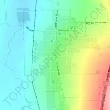
Name: Mona topographic map, elevation, terrain.
Location: Mona, Juab County, Utah, United States (39.79946 -111.86705 39.82485 -111.82693)
Average elevation: 5,000 ft
Minimum elevation: 4,879 ft
Maximum elevation: 5,262 ft
Juab County trails, hiking, mountain biking, running and outdoor activities
Make a donation
Gear up for your next adventure:
As an Amazon Associate, this site earns from qualifying purchases at no extra cost to you.
Other topographic maps
Click on a map to view its topography, its elevation and its terrain.