
Make a donation
Gear up for your next adventure:
As an Amazon Associate, this site earns from qualifying purchases at no extra cost to you.
Topaz Mountain topographic map
Click on the map to display elevation.
Make a donation
Gear up for your next adventure:
As an Amazon Associate, this site earns from qualifying purchases at no extra cost to you.
About this map
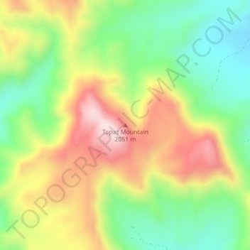
Name: Topaz Mountain topographic map, elevation, terrain.
Location: Topaz Mountain, Juab County, Utah, United States (39.70934 -113.10335 39.70944 -113.10325)
Average elevation: 6,217 ft
Minimum elevation: 5,564 ft
Maximum elevation: 7,034 ft
Juab County trails, hiking, mountain biking, running and outdoor activities
Make a donation
Gear up for your next adventure:
As an Amazon Associate, this site earns from qualifying purchases at no extra cost to you.
Other topographic maps
Click on a map to view its topography, its elevation and its terrain.
Deep Creek Mountains Wilderness Study Area
United States > Utah > Juab County
Average elevation: 6,191 ft
Mona
United States > Utah > Juab County
Mount Nebo, the southernmost and highest mountain in the Wasatch Range, rises 5 miles (8 km) east of Mona to an elevation of 11,928 feet (3,636 m).
Average elevation: 5,000 ft
Make a donation
Gear up for your next adventure:
As an Amazon Associate, this site earns from qualifying purchases at no extra cost to you.