
Make a donation
Gear up for your next adventure:
As an Amazon Associate, this site earns from qualifying purchases at no extra cost to you.
Fulpmes topographic map
Click on the map to display elevation.
Make a donation
Gear up for your next adventure:
As an Amazon Associate, this site earns from qualifying purchases at no extra cost to you.
Fulpmes
Fulpmes est une commune du district d'Innsbruck-Land, au Tyrol (Autriche), il s'agit aussi d'une station de sports d'hiver. Son domaine skiable est connu sous le nom de Schlick 2000, domaine s'étend le long du glacier de Stubai avec un point culminant situé à 3 210 mètres d'altitude. De plus la commune dispose d'une vie nocturne et de mises en place de loisirs attrayants.
Make a donation
Gear up for your next adventure:
As an Amazon Associate, this site earns from qualifying purchases at no extra cost to you.
About this map
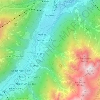
Name: Fulpmes topographic map, elevation, terrain.
Location: Fulpmes, Bezirk Innsbruck-Land, Tyrol, 6166, Autriche (47.10682 11.30127 47.16111 11.38150)
Average elevation: 4,760 ft
Minimum elevation: 2,871 ft
Maximum elevation: 8,809 ft
Make a donation
Gear up for your next adventure:
As an Amazon Associate, this site earns from qualifying purchases at no extra cost to you.
Other topographic maps
Click on a map to view its topography, its elevation and its terrain.
Serles
Autriche > Tyrol > Bezirk Innsbruck-Land > Fulpmes
Le Serles (aussi appelé Waldrastspitze) est une montagne culminant à 2 717 m d'altitude dans les Alpes de Stubai.
Average elevation: 6,680 ft
Make a donation
Gear up for your next adventure:
As an Amazon Associate, this site earns from qualifying purchases at no extra cost to you.
Nördliche Kräulspitze
Autriche > Tyrol > Bezirk Innsbruck-Land > Neustift im Stubaital
Average elevation: 9,370 ft
Make a donation
Gear up for your next adventure:
As an Amazon Associate, this site earns from qualifying purchases at no extra cost to you.