
Carmacks topographic map
Interactive map
Click on the map to display elevation.
About this map
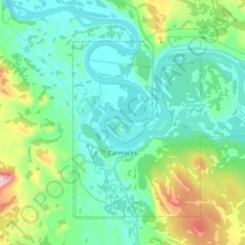
Name: Carmacks topographic map, elevation, terrain.
Location: Carmacks, Yukon, Unorganized, Yukon, Y0B 1C0, Canada (62.06746 -136.32515 62.12979 -136.15159)
Average elevation: 2,034 ft
Minimum elevation: 1,637 ft
Maximum elevation: 3,392 ft
Other topographic maps
Click on a map to view its topography, its elevation and its terrain.