Geolocate

Watertown topographic map

Click on the map to display elevation.

About this map

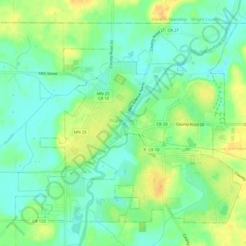
Name: Watertown topographic map, elevation, terrain.

Location: Watertown, Carver County, Minnesota, United States (44.94869 -93.86923 44.97786 -93.81849)

Average elevation: 955 ft

Minimum elevation: 912 ft

Maximum elevation: 1,014 ft

Carver County trails, hiking, mountain biking, running and outdoor activities

Other topographic maps

Click on a map to view its topography, its elevation and its terrain.

Tamarack Lake

United States > Minnesota > Carver County > Victoria

Average elevation: 981 ft

Carver

United States > Minnesota > Carver County > Carver > Carver

Average elevation: 794 ft

Gear up for your next adventure:

🍳Camping Cook Set - Complete cookware for outdoor meals
🛰️Handheld GPS Units - Professional satellite navigators for precise backcountry mapping
🥾Hiking Shoes - Durable and comfortable shoes for trail hiking
📡Handheld GPS Device - Reliable handheld GPS for outdoor navigation
🧢Outdoor Hiking Hat - Sun protection hat for outdoor explorers

As an Amazon Associate, this site earns from qualifying purchases at no extra cost to you.