Geolocate

Philae topographic map

Click on the map to display elevation.

About this map

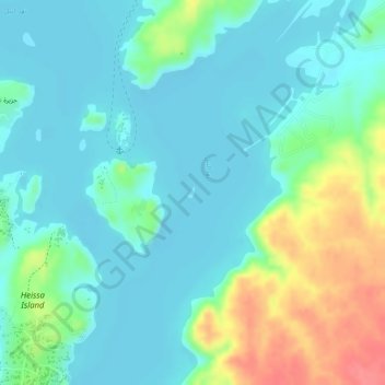
Name: Philae topographic map, elevation, terrain.

Location: Philae, Aswan, Egypt (24.02056 32.88912 24.02140 32.88979)

Average elevation: 423 ft

Minimum elevation: 351 ft

Maximum elevation: 604 ft

Other topographic maps

Click on a map to view its topography, its elevation and its terrain.

Sunken Island of Philae

Egypt > Aswan > Aswan

Average elevation: 420 ft

Gear up for your next adventure:

🥘Titanium Cookware - Durable, featherlight pots and pans for backpacking
🚑Emergency Bivvies - Heat-reflective sleeping bags for survival situations
💧Water Purification System - Clean water on the trail with reliable purifiers
🛡️Bear Spray Outdoor - Protection in bear country hikes
🥤Water Filter Bottle - All‑in‑one filter bottle for safe hydration

As an Amazon Associate, this site earns from qualifying purchases at no extra cost to you.