
Make a donation
Gear up for your next adventure:
As an Amazon Associate, this site earns from qualifying purchases at no extra cost to you.
Glastonbury topographic map
Click on the map to display elevation.
Make a donation
Gear up for your next adventure:
As an Amazon Associate, this site earns from qualifying purchases at no extra cost to you.
Glastonbury
Glastonbury, Connecticut, features a diverse topography characterized by its location along the eastern banks of the Connecticut River, where the terrain begins at a low elevation near the river and gradually ascends into rolling hills. The town encompasses notable elevations such as Kongscut Mountain and Minnechaug Mountain, with peaks reaching around 800 feet. These higher areas provide scenic views of the Hartford skyline and are complemented by regions of dense woodlands, including the expansive Meshomasic State Forest, which is popular for outdoor activities like hiking and fishing.
Make a donation
Gear up for your next adventure:
As an Amazon Associate, this site earns from qualifying purchases at no extra cost to you.
About this map
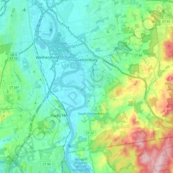
Name: Glastonbury topographic map, elevation, terrain.
Average elevation: 220 ft
Minimum elevation: 0 ft
Maximum elevation: 896 ft
Capitol Planning Region trails, hiking, mountain biking, running and outdoor activities
Make a donation
Gear up for your next adventure:
As an Amazon Associate, this site earns from qualifying purchases at no extra cost to you.
Other topographic maps
Click on a map to view its topography, its elevation and its terrain.
West Suffield
United States > Connecticut > Capitol Planning Region > Suffield
Average elevation: 194 ft
Plantsville
United States > Connecticut > Capitol Planning Region > Southington
Average elevation: 187 ft
Four Corners
United States > Connecticut > Capitol Planning Region > Terramuggus
Average elevation: 469 ft
Willington Hill
United States > Connecticut > Capitol Planning Region > Willington
Average elevation: 646 ft
Make a donation
Gear up for your next adventure:
As an Amazon Associate, this site earns from qualifying purchases at no extra cost to you.
Vernon Center
United States > Connecticut > Capitol Planning Region > Vernon
Average elevation: 348 ft
Griswoldville
United States > Connecticut > Capitol Planning Region > Wethersfield
Average elevation: 112 ft
Clay Arsenal
United States > Connecticut > Capitol Planning Region > Hartford
Average elevation: 59 ft
Make a donation
Gear up for your next adventure:
As an Amazon Associate, this site earns from qualifying purchases at no extra cost to you.
North End
United States > Connecticut > Capitol Planning Region > Southington
Average elevation: 223 ft
Chaffeeville
United States > Connecticut > Capitol Planning Region > Mansfield
Average elevation: 436 ft
West District
United States > Connecticut > Capitol Planning Region > Farmington
Average elevation: 302 ft
Talcott Mountain
United States > Connecticut > Capitol Planning Region > Bloomfield
Average elevation: 499 ft
Make a donation
Gear up for your next adventure:
As an Amazon Associate, this site earns from qualifying purchases at no extra cost to you.
South Wethersfield
United States > Connecticut > Capitol Planning Region > Wethersfield > Griswoldville
Average elevation: 72 ft
Buckingham
United States > Connecticut > Capitol Planning Region > Glastonbury
Average elevation: 430 ft
North Coventry
United States > Connecticut > Capitol Planning Region > Coventry
Average elevation: 640 ft
Make a donation
Gear up for your next adventure:
As an Amazon Associate, this site earns from qualifying purchases at no extra cost to you.
Bishop's Corner
United States > Connecticut > Capitol Planning Region > West Hartford
Average elevation: 154 ft
Talcott Mountain
United States > Connecticut > Capitol Planning Region > Bloomfield
Average elevation: 499 ft
Johnson Hill
United States > Connecticut > Capitol Planning Region > West Hartford
Average elevation: 112 ft
Make a donation
Gear up for your next adventure:
As an Amazon Associate, this site earns from qualifying purchases at no extra cost to you.
Avon Park North
United States > Connecticut > Capitol Planning Region > Avon
Average elevation: 249 ft
Clay Arsenal
United States > Connecticut > Capitol Planning Region > Hartford
Average elevation: 59 ft
Make a donation
Gear up for your next adventure:
As an Amazon Associate, this site earns from qualifying purchases at no extra cost to you.
Holcomb Farm
United States > Connecticut > Capitol Planning Region > Granby > West Granby
Average elevation: 381 ft
Unionville
United States > Connecticut > Capitol Planning Region > Farmington
Average elevation: 315 ft
Make a donation
Gear up for your next adventure:
As an Amazon Associate, this site earns from qualifying purchases at no extra cost to you.
Unionville
United States > Connecticut > Capitol Planning Region > Farmington
Average elevation: 315 ft
Spoonville
United States > Connecticut > Capitol Planning Region > East Granby
Average elevation: 203 ft
Stafford Springs
United States > Connecticut > Capitol Planning Region > Stafford
Average elevation: 656 ft
Make a donation
Gear up for your next adventure:
As an Amazon Associate, this site earns from qualifying purchases at no extra cost to you.
Cottage Grove
United States > Connecticut > Capitol Planning Region > Bloomfield
Average elevation: 102 ft
Barbara Drive
United States > Connecticut > Capitol Planning Region > Windsor Locks
Average elevation: 128 ft
Make a donation
Gear up for your next adventure:
As an Amazon Associate, this site earns from qualifying purchases at no extra cost to you.
Thompsonville
United States > Connecticut > Capitol Planning Region > Enfield
Average elevation: 105 ft