
Refrontolo topographic map
Click on the map to display elevation.
About this map
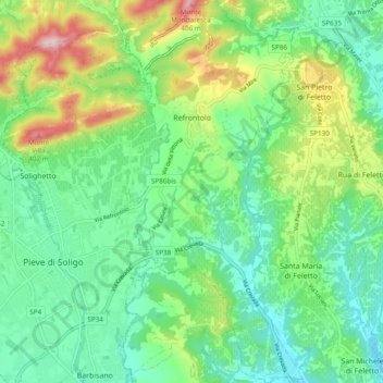
Name: Refrontolo topographic map, elevation, terrain.
Location: Refrontolo, Province of Treviso, Veneto, 31020, Italy (45.87863 12.18996 45.94524 12.23560)
Average elevation: 577 ft
Minimum elevation: 243 ft
Maximum elevation: 1,348 ft
Other topographic maps
Click on a map to view its topography, its elevation and its terrain.
Semonzo del Grappa
Italy > Veneto > Province of Treviso > Borso del Grappa
Average elevation: 1,119 ft
Dus
Italy > Veneto > Province of Treviso > Nervesa della Battaglia > Sovilla
Average elevation: 269 ft
Monte Pizzoc
Italy > Veneto > Province of Treviso > Fregona
Pizzoc is a mountain of the Veneto, Italy. It has an elevation of 1,565 metres.
Average elevation: 4,068 ft
Sant'Andrea oltre il Muson
Italy > Veneto > Province of Treviso > Castelfranco Veneto
Average elevation: 125 ft