Geolocate

Kentwood topographic map

Click on the map to display elevation.

About this map

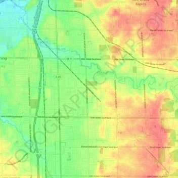
Name: Kentwood topographic map, elevation, terrain.

Location: Kentwood, Kent County, Michigan, United States (42.85449 -85.66486 42.94119 -85.54464)

Average elevation: 709 ft

Minimum elevation: 604 ft

Maximum elevation: 814 ft

Kent County trails, hiking, mountain biking, running and outdoor activities

Other topographic maps

Click on a map to view its topography, its elevation and its terrain.

Crescent Park

United States > Michigan > Kent County > Grand Rapids

Average elevation: 669 ft

Harvard Lake

United States > Michigan > Kent County > Harvard

Average elevation: 876 ft

Lookout Park

United States > Michigan > Kent County > Grand Rapids

Average elevation: 669 ft

Grattan

United States > Michigan > Kent County

Average elevation: 856 ft

Cobb Lake

United States > Michigan > Kent County > Bowne Township

Average elevation: 827 ft

Parnell

United States > Michigan > Kent County > Grattan Township

Average elevation: 850 ft

Grattan

United States > Michigan > Kent County

Average elevation: 856 ft

Kettle Lake

United States > Michigan > Kent County

Average elevation: 784 ft

Richmond Park

United States > Michigan > Kent County > Grand Rapids

Average elevation: 663 ft

Creekside Park

United States > Michigan > Kent County > Lowell

Average elevation: 659 ft

Gear up for your next adventure:

🔌Solar Panel Charger - Charge gear sustainably outdoors
🔦Compact Flashlight - Reliable flashlight for emergencies
🧭Orienteering Set - Complete compass and map reading kit
📱Solar Portable Charger - Solar power bank for charging devices off‑grid
🥾Women's Hiking Boots - Top-rated trail boots with ankle support and superior grip

As an Amazon Associate, this site earns from qualifying purchases at no extra cost to you.