
Make a donation
Gear up for your next adventure:
As an Amazon Associate, this site earns from qualifying purchases at no extra cost to you.
Tanjung Rambutan topographic map
Click on the map to display elevation.
Make a donation
Gear up for your next adventure:
As an Amazon Associate, this site earns from qualifying purchases at no extra cost to you.
Tanjung Rambutan
Tanjung Rambutan is located at an elevation of 60 meters above sea level. The town is situated on the banks of the Kinta River and is surrounded by hills and forests. The town is known for its tropical climate, with temperatures ranging from 22 °C to 32 °C throughout the year.
Make a donation
Gear up for your next adventure:
As an Amazon Associate, this site earns from qualifying purchases at no extra cost to you.
About this map
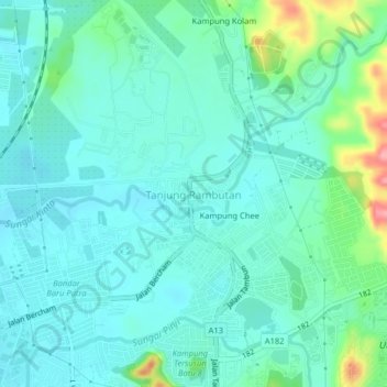
Name: Tanjung Rambutan topographic map, elevation, terrain.
Location: Tanjung Rambutan, Ipoh, Kinta, Perak, 31250, Malaysia (4.65035 101.13686 4.69035 101.17686)
Average elevation: 272 ft
Minimum elevation: 194 ft
Maximum elevation: 577 ft
Make a donation
Gear up for your next adventure:
As an Amazon Associate, this site earns from qualifying purchases at no extra cost to you.
Other topographic maps
Click on a map to view its topography, its elevation and its terrain.
Make a donation
Gear up for your next adventure:
As an Amazon Associate, this site earns from qualifying purchases at no extra cost to you.
Make a donation
Gear up for your next adventure:
As an Amazon Associate, this site earns from qualifying purchases at no extra cost to you.