Waischenfeld topographic map
Interactive map
Click on the map to display elevation.
About this map
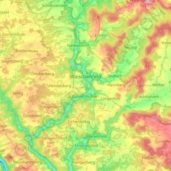
Name: Waischenfeld topographic map, elevation, terrain.
Location: Waischenfeld, Landkreis Bayreuth, Bavaria, 91344, Germany (49.79969 11.25670 49.88290 11.40954)
Average elevation: 1,427 ft
Minimum elevation: 1,014 ft
Maximum elevation: 1,903 ft
Other topographic maps
Click on a map to view its topography, its elevation and its terrain.
95469
Germany > Bavaria > Landkreis Bayreuth > Kirchenlaibach
95469, Kirchenlaibach, Speichersdorf, Landkreis Bayreuth, Bavaria, Germany
Average elevation: 1,522 ft
Görschnitz
Germany > Bavaria > Landkreis Bayreuth > Weidenberg
Görschnitz, Weidenberg, Weidenberg (VGem), Landkreis Bayreuth, Bavaria, 95466, Germany
Average elevation: 1,594 ft
Pegnitz
Germany > Bavaria > Landkreis Bayreuth
Pegnitz, Landkreis Bayreuth, Bavaria, 91257, Germany
Average elevation: 1,591 ft
Gefrees
Germany > Bavaria > Landkreis Bayreuth
Gefrees, Landkreis Bayreuth, Bavaria, 95482, Germany
Average elevation: 1,919 ft