
Dease Lake topographic map
Click on the map to display elevation.
Dease Lake
Dease Lake has a subarctic climate (Köppen Dfc), typical of northern British Columbia. Summers are mild, coupled with chilly nights while winters are severely cold and snowy, with annual snowfall averaging 212.8 cm (83.78 in). Autumn typically begins by early September and lasts into October when winter begins. Winter can last into late March or sometimes early April. Spring usually lasts until late May or early June, after when summer begins. Due to Dease Lake's high elevation, snowfall is possible during any month of the year.
About this map
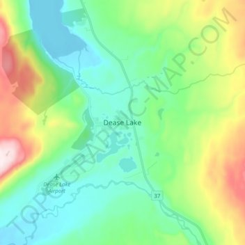
Name: Dease Lake topographic map, elevation, terrain.
Average elevation: 2,946 ft
Minimum elevation: 2,461 ft
Maximum elevation: 4,226 ft
Other topographic maps
Click on a map to view its topography, its elevation and its terrain.
Ball Creek
Canada > British Columbia > Regional District of Kitimat-Stikine > Area F (Dease Lake)
Average elevation: 4,157 ft
Sixteen Mile Creek
Canada > British Columbia > Regional District of Kitimat-Stikine > Area F (Dease Lake)
Average elevation: 4,157 ft
Beaver Lake
Canada > British Columbia > Regional District of Kitimat-Stikine > Area F (Dease Lake) > Dease Lake
Average elevation: 2,838 ft
Dease Lake
Canada > British Columbia > Regional District of Kitimat-Stikine > Area F (Dease Lake)
Average elevation: 3,701 ft