Geolocate

Foster topographic map

Click on the map to display elevation.

About this map

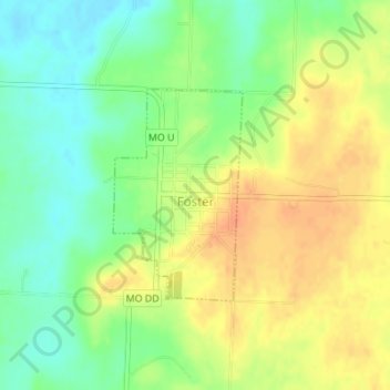
Name: Foster topographic map, elevation, terrain.

Location: Foster, Bates County, Missouri, 64745, United States (38.15879 -94.51427 38.17347 -94.50287)

Average elevation: 830 ft

Minimum elevation: 761 ft

Maximum elevation: 899 ft

Bates County trails, hiking, mountain biking, running and outdoor activities

Other topographic maps

Click on a map to view its topography, its elevation and its terrain.

Johnstown

United States > Missouri > Bates County

Average elevation: 823 ft

Hudson

United States > Missouri > Bates County

Average elevation: 873 ft

Gear up for your next adventure:

🧥Men's Rain Shells - Premium waterproof and breathable jackets for mountain weather
🧭Outdoor Navigation Book - Learn advanced navigation skills
📚USA Hiking Guide Books - Top trail guides and map books
🩳Quick‑Dry Hiking Shorts - Comfortable and quick‑dry shorts for summer hiking
🥄Camping Utensil Set - Lightweight utensils for outdoor meals

As an Amazon Associate, this site earns from qualifying purchases at no extra cost to you.