Geolocate

Stet topographic map

Click on the map to display elevation.

About this map

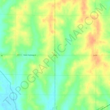
Name: Stet topographic map, elevation, terrain.

Location: Stet, Carroll County, Missouri, United States (39.40307 -93.77883 39.44307 -93.73883)

Average elevation: 791 ft

Minimum elevation: 725 ft

Maximum elevation: 853 ft

Carroll County trails, hiking, mountain biking, running and outdoor activities

Other topographic maps

Click on a map to view its topography, its elevation and its terrain.

Bogard

United States > Missouri > Carroll County

Average elevation: 840 ft

Bosworth

United States > Missouri > Carroll County

Average elevation: 761 ft

De Witt

United States > Missouri > Carroll County

Average elevation: 679 ft

Hale

United States > Missouri > Carroll County

Average elevation: 768 ft

Norborne

United States > Missouri > Carroll County

Average elevation: 689 ft

Tina

United States > Missouri > Carroll County

Average elevation: 735 ft

Gear up for your next adventure:

🪶Paracord Bracelet - Survival bracelet with built‑in tools
🧭Outdoor Navigation Book - Learn advanced navigation skills
🪶Survival Guide Book - Expert advice for emergency preparedness
🎁Geography Themed Gifts - Unique gift ideas for map lovers and geography enthusiasts
🔥Plasma Lighters - Windproof lighters that work in any weather condition

As an Amazon Associate, this site earns from qualifying purchases at no extra cost to you.