
Make a donation
Gear up for your next adventure:
As an Amazon Associate, this site earns from qualifying purchases at no extra cost to you.
Harrisville topographic map
Click on the map to display elevation.
Make a donation
Gear up for your next adventure:
As an Amazon Associate, this site earns from qualifying purchases at no extra cost to you.
About this map
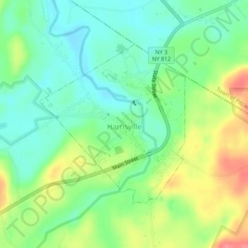
Name: Harrisville topographic map, elevation, terrain.
Average elevation: 820 ft
Minimum elevation: 728 ft
Maximum elevation: 971 ft
Lewis County trails, hiking, mountain biking, running and outdoor activities
Make a donation
Gear up for your next adventure:
As an Amazon Associate, this site earns from qualifying purchases at no extra cost to you.
Other topographic maps
Click on a map to view its topography, its elevation and its terrain.
Beaver River
United States > New York > Lewis County > Town of Croghan > Village of Croghan
Average elevation: 840 ft
Boonville Forest Preserve Detached Parcel
United States > New York > Lewis County
Average elevation: 1,165 ft
Make a donation
Gear up for your next adventure:
As an Amazon Associate, this site earns from qualifying purchases at no extra cost to you.