Geolocate

Panton topographic map

Click on the map to display elevation.

About this map

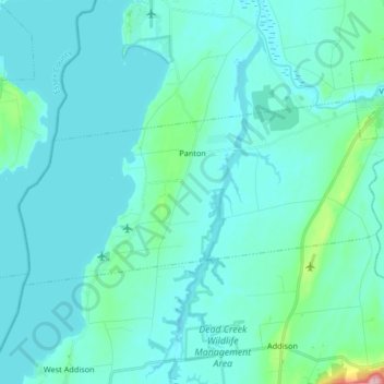
Name: Panton topographic map, elevation, terrain.

Location: Panton, Addison County, Vermont, 05491, United States (44.10784 -73.41578 44.16526 -73.24998)

Average elevation: 138 ft

Minimum elevation: 79 ft

Maximum elevation: 666 ft

Addison County trails, hiking, mountain biking, running and outdoor activities

Other topographic maps

Click on a map to view its topography, its elevation and its terrain.

Bristol

United States > Vermont > Addison County > Bristol > Bristol

Average elevation: 876 ft

South Mountain

United States > Vermont > Addison County > Bristol

Average elevation: 1,939 ft

Richville

United States > Vermont > Addison County > Shoreham

Average elevation: 322 ft

South Lincoln

United States > Vermont > Addison County > Lincoln

Average elevation: 1,457 ft

Bread Loaf

United States > Vermont > Addison County > Ripton

Average elevation: 1,631 ft

Chimney Point

United States > Vermont > Addison County > Addison

Average elevation: 105 ft

Gear up for your next adventure:

🛶Inflatable Kayak - Portable kayak for rivers, lakes, and expeditions
🔥Fast-Boil Camping Stoves - Efficient cooking systems for quick trail meals
🧤Tactile Hiking Gloves - Keep hands warm while operating GPS and smartphone screens
🎒Hydration Pack - Hands‑free water reservoir for long hikes
🕶️GPS Smartphone Mount - Secure mount for phone navigation

As an Amazon Associate, this site earns from qualifying purchases at no extra cost to you.