
Make a donation
Gear up for your next adventure:
As an Amazon Associate, this site earns from qualifying purchases at no extra cost to you.
Clearview topographic map
Click on the map to display elevation.
Make a donation
Gear up for your next adventure:
As an Amazon Associate, this site earns from qualifying purchases at no extra cost to you.
About this map
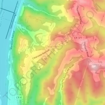
Name: Clearview topographic map, elevation, terrain.
Location: Clearview, Ohio County, West Virginia, United States (40.13096 -80.70014 40.14816 -80.67469)
Average elevation: 991 ft
Minimum elevation: 610 ft
Maximum elevation: 1,332 ft
Ohio County trails, hiking, mountain biking, running and outdoor activities
Make a donation
Gear up for your next adventure:
As an Amazon Associate, this site earns from qualifying purchases at no extra cost to you.
Other topographic maps
Click on a map to view its topography, its elevation and its terrain.
Pleasant Valley
United States > West Virginia > Ohio County > Wheeling > Pleasant Valley
Average elevation: 932 ft
Make a donation
Gear up for your next adventure:
As an Amazon Associate, this site earns from qualifying purchases at no extra cost to you.