
Mount Spokane topographic map
Click on the map to display elevation.
About this map
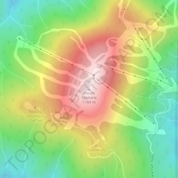
Name: Mount Spokane topographic map, elevation, terrain.
Location: Mount Spokane, Spokane County, Washington, United States (47.92124 -117.11414 47.92134 -117.11404)
Average elevation: 4,839 ft
Minimum elevation: 3,973 ft
Maximum elevation: 5,873 ft
Spokane County trails, hiking, mountain biking, running and outdoor activities
Other topographic maps
Click on a map to view its topography, its elevation and its terrain.
Spokane
United States > Washington > Spokane County
Spokane is located on the Spokane River in eastern Washington at an elevation of 1,843 feet (562 m) above sea level, about 18 miles (29 km) from Idaho, 92 miles (148 km) south of the Canadian border, 229 miles (369 km) due east of Seattle, and 279 miles (449 km) southwest of Calgary. The lowest elevation in…
Average elevation: 2,149 ft
Liberty Lake
United States > Washington > Spokane County
Areas east of Liberty Lake Road and areas north of Appleway Road lie on the relatively flat land along the floor of the Spokane Valley. Elevations there range from between 2,000 feet above sea level at the river to around 2,150 feet around Liberty Lake Elementary School. The areas west of Liberty Lake Road and…
Average elevation: 2,113 ft
Deer Park
United States > Washington > Spokane County
Deer Park is located at 47°57′25″N 117°28′13″W / 47.95694°N 117.47028°W / 47.95694; -117.47028 (47.956922, -117.470230), at an elevation of 2,123 feet (647 m) above sea level.
Average elevation: 2,159 ft
Cheney
United States > Washington > Spokane County
Cheney is located at 47°29′19″N 117°34′43″W / 47.48861°N 117.57861°W / 47.48861; -117.57861 (47.488634, -117.578581), at an elevation of 2,400 ft (730 m).
Average elevation: 2,388 ft
Airway Heights
United States > Washington > Spokane County
The community lies in the northeastern corner of the flat Columbia Plateau. While the plateau tends to be flat, the terrain locally is quite rugged as it is part of the Channeled Scablands. The "heights" in the city's name references its location at a higher elevation than the city center of Spokane. Traveling…
Average elevation: 2,375 ft
Town and Country
United States > Washington > Spokane County
The city of Spokane surrounds the CDP on three sides: the east, south and west. The city's street grid continues into Town and Country uninterrupted in the east, though it breaks down in the west along the bluff leading up to Five Mile Prairie. The bulk of the CDP lies on flat ground like the surrounding north…
Average elevation: 2,096 ft
Spokane
United States > Washington > Spokane County
Spokane is located on the Spokane River in eastern Washington at an elevation of 1,843 feet (562 m) above sea level, about eighteen miles (29 km) west of the Idaho border, 92 miles (148 km) south of the Canadian border, 229 miles (369 km) due east of Seattle, and 279 miles (449 km) southwest of Calgary,…
Average elevation: 2,149 ft
Spokane
United States > Washington > Spokane County
Spokane is located on the Spokane River in eastern Washington at an elevation of 1,843 feet (562 m) above sea level, about 18 miles (29 km) from Idaho, 92 miles (148 km) south of the Canadian border, 229 miles (369 km) due east of Seattle, and 279 miles (449 km) southwest of Calgary. The lowest elevation in…
Average elevation: 2,149 ft
Liberty Lake
United States > Washington > Spokane County
Areas east of Liberty Lake Road and areas north of Appleway Road lie on the relatively flat land along the floor of the Spokane Valley. Elevations there range from between 2,000 feet above sea level at the river to around 2,150 feet around Liberty Lake Elementary School. The areas west of Liberty Lake Road and…
Average elevation: 2,113 ft
Dishman Hills Natural Resources Conservation Area
United States > Washington > Spokane County > Spokane Valley
Average elevation: 2,126 ft
Cheney
United States > Washington > Spokane County
Cheney is located at 47°29′19″N 117°34′43″W / 47.48861°N 117.57861°W / 47.48861; -117.57861 (47.488634, -117.578581), at an elevation of 2,400 ft (730 m).
Average elevation: 2,388 ft
Liberty Lake
United States > Washington > Spokane County
Areas east of Liberty Lake Road and areas north of Appleway Road lie on the relatively flat land along the floor of the Spokane Valley. Elevations there range from between 2,000 feet above sea level at the river to around 2,150 feet around Liberty Lake Elementary School. The areas west of Liberty Lake Road and…
Average elevation: 2,113 ft
Cheney
United States > Washington > Spokane County
Cheney is located at 47°29′19″N 117°34′43″W / 47.48861°N 117.57861°W / 47.48861; -117.57861 (47.488634, -117.578581), at an elevation of 2,400 ft (730 m).
Average elevation: 2,388 ft
Airway Heights
United States > Washington > Spokane County
The community lies in the northeastern corner of the flat Columbia Plateau. While the plateau tends to be flat, the terrain locally is quite rugged as it is part of the Channeled Scablands. The "heights" in the city's name references its location at a higher elevation than the city center of Spokane. Traveling…
Average elevation: 2,375 ft
Spokane
United States > Washington > Spokane County
Spokane is located on the Spokane River in eastern Washington at an elevation of 1,843 feet (562 m) above sea level, about 18 miles (29 km) from Idaho, 92 miles (148 km) south of the Canadian border, 229 miles (369 km) due east of Seattle, and 279 miles (449 km) southwest of Calgary. The lowest elevation in…
Average elevation: 2,149 ft