
Make a donation
Gear up for your next adventure:
As an Amazon Associate, this site earns from qualifying purchases at no extra cost to you.
Liberty Lake topographic map
Click on the map to display elevation.
Make a donation
Gear up for your next adventure:
As an Amazon Associate, this site earns from qualifying purchases at no extra cost to you.
Liberty Lake
Areas east of Liberty Lake Road and areas north of Appleway Road lie on the relatively flat land along the floor of the Spokane Valley. Elevations there range from between 2,000 feet above sea level at the river to around 2,150 feet around Liberty Lake Elementary School. The areas west of Liberty Lake Road and south of Appleway Road show far more topographical relief, rising from around 2,100 feet to over 2,600 feet on Carlson Hill. Kramer Hill, which rises just beyond the eastern limit of the city, quickly rises to above 2,700 feet. While Mica Peak, which rises beyond the southern shore of the lake, climbs to nearly 5,200 feet.
Make a donation
Gear up for your next adventure:
As an Amazon Associate, this site earns from qualifying purchases at no extra cost to you.
About this map
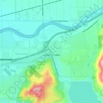
Name: Liberty Lake topographic map, elevation, terrain.
Location: Liberty Lake, Spokane County, Washington, United States (47.64954 -117.14347 47.68995 -117.06333)
Average elevation: 2,113 ft
Minimum elevation: 1,978 ft
Maximum elevation: 2,677 ft
Spokane County trails, hiking, mountain biking, running and outdoor activities
Make a donation
Gear up for your next adventure:
As an Amazon Associate, this site earns from qualifying purchases at no extra cost to you.
Other topographic maps
Click on a map to view its topography, its elevation and its terrain.
Mica Peak
United States > Washington > Spokane County
Mica Peak is the name of two separate mountain summits in the United States located approximately 5.49 miles (9 km) apart; one in Spokane County, Washington and the other in Kootenai County, Idaho. The two peaks are located along the same ridge, which separates the Spokane Valley and Rathdrum Prairie from the…
Average elevation: 4,301 ft
Make a donation
Gear up for your next adventure:
As an Amazon Associate, this site earns from qualifying purchases at no extra cost to you.
Make a donation
Gear up for your next adventure:
As an Amazon Associate, this site earns from qualifying purchases at no extra cost to you.
Make a donation
Gear up for your next adventure:
As an Amazon Associate, this site earns from qualifying purchases at no extra cost to you.
Make a donation
Gear up for your next adventure:
As an Amazon Associate, this site earns from qualifying purchases at no extra cost to you.
Mica Peak
United States > Washington > Spokane County
Mica Peak is the name of two separate mountain summits in the United States located approximately 5.49 miles (9 km) apart; one in Spokane County, Washington and the other in Kootenai County, Idaho. The two peaks are located along the same ridge, which separates the Spokane Valley and Rathdrum Prairie from the…
Average elevation: 4,301 ft
East Spokane
United States > Washington > Spokane County > Spokane Valley > East Spokane
Average elevation: 2,051 ft
Make a donation
Gear up for your next adventure:
As an Amazon Associate, this site earns from qualifying purchases at no extra cost to you.