Geolocate

Garrison topographic map

Click on the map to display elevation.

About this map

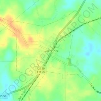
Name: Garrison topographic map, elevation, terrain.

Location: Garrison, Nacogdoches County, Texas, United States (31.81355 -94.51013 31.83519 -94.47994)

Average elevation: 381 ft

Minimum elevation: 325 ft

Maximum elevation: 436 ft

Nacogdoches County trails, hiking, mountain biking, running and outdoor activities

Other topographic maps

Click on a map to view its topography, its elevation and its terrain.

Flower Mountain

United States > Texas > Nacogdoches County

Average elevation: 600 ft

Happy Valley

United States > Texas > Nacogdoches County

Average elevation: 371 ft

Sacul

United States > Texas > Nacogdoches County > Sacul

Average elevation: 322 ft

Douglass

United States > Texas > Nacogdoches County > Douglass

Average elevation: 341 ft

Linn Flat

United States > Texas > Nacogdoches County > Linn Flat

Average elevation: 413 ft

Gear up for your next adventure:

🚁Photography Drones - Capture stunning aerial views of landforms and topography
⛑️Personal Locator Beacon - Safety beacon for emergencies
🔦LED Headlamp - Bright and durable LED headlamp for night navigation
📷Action Camera - Capture your outdoor adventures in HD
🧥Waterproof Jacket for Hiking - Breathable and rugged rain jacket for outdoor excursions

As an Amazon Associate, this site earns from qualifying purchases at no extra cost to you.