
Dunellen topographic map
Click on the map to display elevation.
About this map
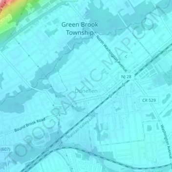
Name: Dunellen topographic map, elevation, terrain.
Location: Dunellen, Middlesex County, New Jersey, United States (40.58073 -74.47809 40.59925 -74.45232)
Average elevation: 69 ft
Minimum elevation: 36 ft
Maximum elevation: 466 ft
Middlesex County trails, hiking, mountain biking, running and outdoor activities
Other topographic maps
Click on a map to view its topography, its elevation and its terrain.
Six Mile Run
United States > New Jersey > Middlesex County > North Brunswick > Adams
Average elevation: 112 ft
Orchard Heights
United States > New Jersey > Middlesex County > East Brunswick Township
Average elevation: 105 ft
Shore View
United States > New Jersey > Middlesex County > Woodbridge Township > Colonia
Average elevation: 95 ft
Highland Park
United States > New Jersey > Middlesex County > Highland Park > Highland Park
Average elevation: 79 ft
Dunhams Corners
United States > New Jersey > Middlesex County > East Brunswick Township > Dunhams Corners
Average elevation: 108 ft
Middlesex
United States > New Jersey > Middlesex County > Middlesex > Middlesex
Average elevation: 125 ft
Farrington Lake Heights
United States > New Jersey > Middlesex County > East Brunswick Township > Farrington Lake Heights
Average elevation: 89 ft
Bicentennial Park
United States > New Jersey > Middlesex County > East Brunswick Township > Farrington Lake Heights
Average elevation: 79 ft
Berdines Corners
United States > New Jersey > Middlesex County > North Brunswick
Average elevation: 95 ft
South Brunswick Terrace
United States > New Jersey > Middlesex County > South Brunswick
Average elevation: 128 ft
Woodbridge
United States > New Jersey > Middlesex County > Woodbridge Township
Average elevation: 52 ft
New Market
United States > New Jersey > Middlesex County > Piscataway Township
Average elevation: 75 ft
Lincoln Park
United States > New Jersey > Middlesex County > New Brunswick > Lincoln Park
Average elevation: 92 ft