
Make a donation
Gear up for your next adventure:
As an Amazon Associate, this site earns from qualifying purchases at no extra cost to you.
El Prado topographic map
Click on the map to display elevation.
Make a donation
Gear up for your next adventure:
As an Amazon Associate, this site earns from qualifying purchases at no extra cost to you.
About this map
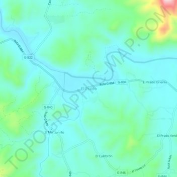
Name: El Prado topographic map, elevation, terrain.
Average elevation: 551 ft
Minimum elevation: 377 ft
Maximum elevation: 1,289 ft
Make a donation
Gear up for your next adventure:
As an Amazon Associate, this site earns from qualifying purchases at no extra cost to you.
Other topographic maps
Click on a map to view its topography, its elevation and its terrain.
Melipilla
Chile > Región Metropolitana de Santiago > Provincia de Melipilla
Average elevation: 1,207 ft
María Pinto
Chile > Región Metropolitana de Santiago > Provincia de Melipilla
Average elevation: 1,142 ft
Curacaví
Chile > Región Metropolitana de Santiago > Provincia de Melipilla
Average elevation: 1,906 ft
Make a donation
Gear up for your next adventure:
As an Amazon Associate, this site earns from qualifying purchases at no extra cost to you.
Curacaví
Chile > Región Metropolitana de Santiago > Provincia de Melipilla
Average elevation: 1,906 ft
Melipilla
Chile > Región Metropolitana de Santiago > Provincia de Melipilla
Average elevation: 1,207 ft
María Pinto
Chile > Región Metropolitana de Santiago > Provincia de Melipilla
Average elevation: 1,142 ft
Make a donation
Gear up for your next adventure:
As an Amazon Associate, this site earns from qualifying purchases at no extra cost to you.
Melipilla
Chile > Región Metropolitana de Santiago > Provincia de Melipilla
Average elevation: 1,207 ft
Make a donation
Gear up for your next adventure:
As an Amazon Associate, this site earns from qualifying purchases at no extra cost to you.