
Make a donation
Gear up for your next adventure:
As an Amazon Associate, this site earns from qualifying purchases at no extra cost to you.
María Pinto topographic map
Click on the map to display elevation.
Make a donation
Gear up for your next adventure:
As an Amazon Associate, this site earns from qualifying purchases at no extra cost to you.
About this map
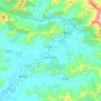
Name: María Pinto topographic map, elevation, terrain.
Average elevation: 1,142 ft
Minimum elevation: 397 ft
Maximum elevation: 6,142 ft
Make a donation
Gear up for your next adventure:
As an Amazon Associate, this site earns from qualifying purchases at no extra cost to you.
Other topographic maps
Click on a map to view its topography, its elevation and its terrain.
El Trigal
Chile > Región Metropolitana de Santiago > Provincia de Melipilla > Melipilla > San José
Average elevation: 531 ft
Porvenir
Chile > Región Metropolitana de Santiago > Provincia de Melipilla > Melipilla > Codigua
Average elevation: 351 ft
Las Arañas
Chile > Región Metropolitana de Santiago > Provincia de Melipilla > San Pedro
Average elevation: 548 ft
Make a donation
Gear up for your next adventure:
As an Amazon Associate, this site earns from qualifying purchases at no extra cost to you.
Tantehue
Chile > Región Metropolitana de Santiago > Provincia de Melipilla > Melipilla
Average elevation: 594 ft
Santa Elisa
Chile > Región Metropolitana de Santiago > Provincia de Melipilla > Melipilla > El Pimiento
Average elevation: 1,037 ft
Puangue
Chile > Región Metropolitana de Santiago > Provincia de Melipilla > Melipilla
Average elevation: 476 ft
Las Arenas
Chile > Región Metropolitana de Santiago > Provincia de Melipilla > San Pedro
Average elevation: 492 ft
Make a donation
Gear up for your next adventure:
As an Amazon Associate, this site earns from qualifying purchases at no extra cost to you.
Mirador Padre Hurtado
Chile > Región Metropolitana de Santiago > Provincia de Melipilla > Curacaví > Pangue Alto
Average elevation: 2,201 ft
Pomaire
Chile > Región Metropolitana de Santiago > Provincia de Melipilla > Melipilla
Average elevation: 843 ft
La Portada
Chile > Región Metropolitana de Santiago > Provincia de Melipilla > Curacaví
Average elevation: 984 ft
Codigua
Chile > Región Metropolitana de Santiago > Provincia de Melipilla > Melipilla
Average elevation: 371 ft
Make a donation
Gear up for your next adventure:
As an Amazon Associate, this site earns from qualifying purchases at no extra cost to you.
Loica Arriba
Chile > Región Metropolitana de Santiago > Provincia de Melipilla > San Pedro > Loica Arriba
Average elevation: 732 ft
Cerrillos
Chile > Región Metropolitana de Santiago > Provincia de Melipilla > Curacaví
Average elevation: 656 ft
Patagüilla
Chile > Región Metropolitana de Santiago > Provincia de Melipilla > Curacaví > Patagüilla
Average elevation: 784 ft
Maitén
Chile > Región Metropolitana de Santiago > Provincia de Melipilla > San Pedro
Average elevation: 738 ft
Make a donation
Gear up for your next adventure:
As an Amazon Associate, this site earns from qualifying purchases at no extra cost to you.
El Limonal
Chile > Región Metropolitana de Santiago > Provincia de Melipilla > Melipilla > San José
Average elevation: 568 ft
San José
Chile > Región Metropolitana de Santiago > Provincia de Melipilla > Melipilla
Average elevation: 554 ft
San José
Chile > Región Metropolitana de Santiago > Provincia de Melipilla > Melipilla
Average elevation: 554 ft
Ostolazas
Chile > Región Metropolitana de Santiago > Provincia de Melipilla > Melipilla
Average elevation: 630 ft
Make a donation
Gear up for your next adventure:
As an Amazon Associate, this site earns from qualifying purchases at no extra cost to you.
Pomaire
Chile > Región Metropolitana de Santiago > Provincia de Melipilla > Melipilla
Average elevation: 843 ft
San Juan de Popeta
Chile > Región Metropolitana de Santiago > Provincia de Melipilla > Melipilla
Average elevation: 440 ft