
Dadeldhura topographic map
Interactive map
Click on the map to display elevation.
About this map
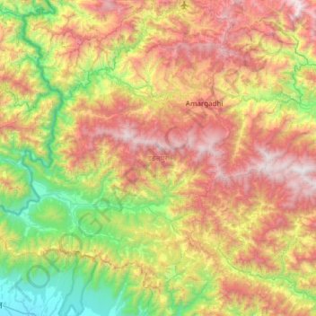
Name: Dadeldhura topographic map, elevation, terrain.
Location: Dadeldhura, Sudurpashchim Province, 10300, Nepal (28.99372 80.18375 29.42510 80.78566)
Average elevation: 4,049 ft
Minimum elevation: 656 ft
Maximum elevation: 8,855 ft
Other topographic maps
Click on a map to view its topography, its elevation and its terrain.
Kailali
Nepal > Sudurpashchim Province
Kailali, Sudurpashchim Province, Nepal
Average elevation: 1,693 ft
Chure
Nepal > Sudurpashchim Province > Kailali
Chure, Kailali, Sudurpashchim Province, Nepal
Average elevation: 3,081 ft
Ramaroshan
Nepal > Sudurpashchim Province > Achham
Ramaroshan, Achham, Sudurpashchim Province, Nepal
Average elevation: 6,965 ft
Jayagad, Achham
Nepal > Sudurpashchim Province > Achham
Jayagad, Achham, Bannigadhi Jayagadh, Achham, Sudurpashchim Province, Nepal
Average elevation: 4,078 ft