
Make a donation
Gear up for your next adventure:
As an Amazon Associate, this site earns from qualifying purchases at no extra cost to you.
Union Ridge topographic map
Click on the map to display elevation.
Make a donation
Gear up for your next adventure:
As an Amazon Associate, this site earns from qualifying purchases at no extra cost to you.
About this map
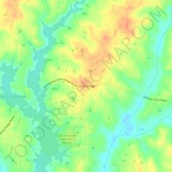
Name: Union Ridge topographic map, elevation, terrain.
Location: Union Ridge, Alamance County, North Carolina, United States (36.18764 -79.42002 36.22764 -79.38002)
Average elevation: 620 ft
Minimum elevation: 551 ft
Maximum elevation: 699 ft
Alamance County trails, hiking, mountain biking, running and outdoor activities
Make a donation
Gear up for your next adventure:
As an Amazon Associate, this site earns from qualifying purchases at no extra cost to you.
Other topographic maps
Click on a map to view its topography, its elevation and its terrain.
Make a donation
Gear up for your next adventure:
As an Amazon Associate, this site earns from qualifying purchases at no extra cost to you.
Woodruff Pond
United States > North Carolina > Alamance County > Burlington > Rockwood Acres
Average elevation: 669 ft