
Make a donation
Gear up for your next adventure:
As an Amazon Associate, this site earns from qualifying purchases at no extra cost to you.
Travis Creek topographic map
Click on the map to display elevation.
Make a donation
Gear up for your next adventure:
As an Amazon Associate, this site earns from qualifying purchases at no extra cost to you.
About this map
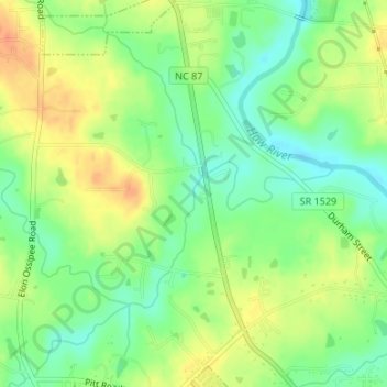
Name: Travis Creek topographic map, elevation, terrain.
Average elevation: 630 ft
Minimum elevation: 561 ft
Maximum elevation: 705 ft
Alamance County trails, hiking, mountain biking, running and outdoor activities
Make a donation
Gear up for your next adventure:
As an Amazon Associate, this site earns from qualifying purchases at no extra cost to you.
Other topographic maps
Click on a map to view its topography, its elevation and its terrain.
Make a donation
Gear up for your next adventure:
As an Amazon Associate, this site earns from qualifying purchases at no extra cost to you.
Lakeside
United States > North Carolina > Alamance County > Burlington > Lakeside
Average elevation: 623 ft
Granite Village
United States > North Carolina > Alamance County > Haw River > Granite Village
Average elevation: 571 ft
Cooper Estates
United States > North Carolina > Alamance County > Graham > Cooper Estates
Average elevation: 548 ft
Brookwood Subdivision
United States > North Carolina > Alamance County > Burlington > Brookwood Subdivision
Average elevation: 650 ft
Make a donation
Gear up for your next adventure:
As an Amazon Associate, this site earns from qualifying purchases at no extra cost to you.
Pinewood Forest
United States > North Carolina > Alamance County > Burlington
Average elevation: 630 ft
Beverly Hills
United States > North Carolina > Alamance County > Burlington > Beverly Hills
Average elevation: 607 ft
Make a donation
Gear up for your next adventure:
As an Amazon Associate, this site earns from qualifying purchases at no extra cost to you.