Geolocate

Hampden (CDP) topographic map

Click on the map to display elevation.

About this map

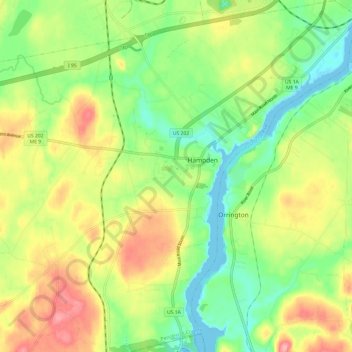
Name: Hampden (CDP) topographic map, elevation, terrain.

Location: Hampden (CDP), Penobscot County, Maine, United States (44.69769 -68.87062 44.78339 -68.78128)

Average elevation: 148 ft

Minimum elevation: -16 ft

Maximum elevation: 344 ft

Penobscot County trails, hiking, mountain biking, running and outdoor activities

Other topographic maps

Click on a map to view its topography, its elevation and its terrain.

Lincoln

United States > Maine > Penobscot County > Lincoln

Average elevation: 272 ft

Houston Island

United States > Maine > Penobscot County > Winn

Average elevation: 243 ft

Carroll

United States > Maine > Penobscot County

Average elevation: 778 ft

Fairmont Park

United States > Maine > Penobscot County > Bangor

Average elevation: 148 ft

Meadow Brook

United States > Maine > Penobscot County

Average elevation: 325 ft

Gear up for your next adventure:

🖼️Topo Map Wall Art - Decorative topographic prints of famous peaks and regions
📶Satellite Messenger - Communication device off‑grid
🏥Hiking First Aid Kits - Comprehensive medical kits for remote trail injuries
🧢Outdoor Hiking Hat - Sun protection hat for outdoor explorers
🛠️Backpacking Tool Kit - Essential toolkit for outdoor repairs

As an Amazon Associate, this site earns from qualifying purchases at no extra cost to you.