
Make a donation
Gear up for your next adventure:
As an Amazon Associate, this site earns from qualifying purchases at no extra cost to you.
City of Rome topographic map
Click on the map to display elevation.
Make a donation
Gear up for your next adventure:
As an Amazon Associate, this site earns from qualifying purchases at no extra cost to you.
City of Rome
The critical east/west American trade route through the frontier was improved by construction of the Erie Canal. On July 4, 1817, construction on the canal began in Rome. The Erie Canal reaches a summit in Rome, attaining an elevation of 420 feet. The first phase was completed in 1825, connecting the Hudson River by waterway to the Great Lakes. It resulted in an increase in trade and traffic between communities around the Great Lakes and New York City, stimulating development all along the route.
Make a donation
Gear up for your next adventure:
As an Amazon Associate, this site earns from qualifying purchases at no extra cost to you.
About this map
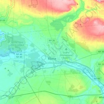
Name: City of Rome topographic map, elevation, terrain.
Location: City of Rome, Oneida County, New York, United States (43.16906 -75.66687 43.28162 -75.34077)
Average elevation: 623 ft
Minimum elevation: 377 ft
Maximum elevation: 1,385 ft
Oneida County trails, hiking, mountain biking, running and outdoor activities
Make a donation
Gear up for your next adventure:
As an Amazon Associate, this site earns from qualifying purchases at no extra cost to you.
Other topographic maps
Click on a map to view its topography, its elevation and its terrain.
West Canada Creek
United States > New York > Oneida County > Town of Trenton
Average elevation: 794 ft
Make a donation
Gear up for your next adventure:
As an Amazon Associate, this site earns from qualifying purchases at no extra cost to you.
Lee Town Park
United States > New York > Oneida County > Lake Delta > Town of Lee
Average elevation: 604 ft
Make a donation
Gear up for your next adventure:
As an Amazon Associate, this site earns from qualifying purchases at no extra cost to you.