Geolocate

Downtown topographic map

Click on the map to display elevation.

About this map

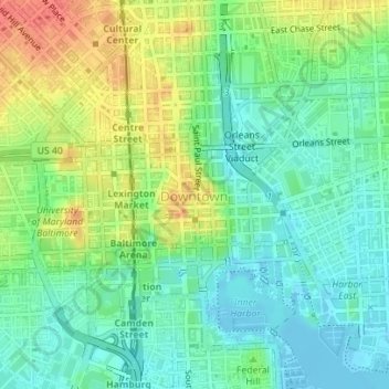
Name: Downtown topographic map, elevation, terrain.

Location: Downtown, Baltimore, Maryland, United States (39.28746 -76.62388 39.29514 -76.60473)

Average elevation: 66 ft

Minimum elevation: -33 ft

Maximum elevation: 174 ft

Maryland trails, hiking, mountain biking, running and outdoor activities

Other topographic maps

Click on a map to view its topography, its elevation and its terrain.

Ravens' Walk

United States > Maryland > Baltimore

Average elevation: 49 ft

Riverside Park

United States > Maryland > Baltimore

Average elevation: 16 ft

Gear up for your next adventure:

🪶Thermal Camp Blanket - Extra warmth for cold nights
📶Vehicle Signal Boosters - Improve reception in rural areas while driving to trailheads
🔭Compact Binoculars - HD vision for scouting terrain and identifying distant landmarks
🚁Photography Drones - Capture stunning aerial views of landforms and topography
🎒Waterproof Dry Bags - Keep your electronics and maps dry inside your pack

As an Amazon Associate, this site earns from qualifying purchases at no extra cost to you.