
Atlanta topographic map
Click on the map to display elevation.
About this map
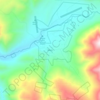
Name: Atlanta topographic map, elevation, terrain.
Location: Atlanta, Elmore County, Idaho, 83601, United States (43.78157 -115.14675 43.82157 -115.10675)
Average elevation: 5,971 ft
Minimum elevation: 5,180 ft
Maximum elevation: 7,648 ft
Elmore County trails, hiking, mountain biking, running and outdoor activities
Other topographic maps
Click on a map to view its topography, its elevation and its terrain.
Glenns Ferry
United States > Idaho > Elmore County
Glenns Ferry is located at 42°57′7″N 115°18′4″W / 42.95194°N 115.30111°W / 42.95194; -115.30111 (42.951954, -115.301132), at an elevation of 2,569 feet (783 m) above sea level.
Average elevation: 2,618 ft