
Caledon topographic map
Click on the map to display elevation.
About this map
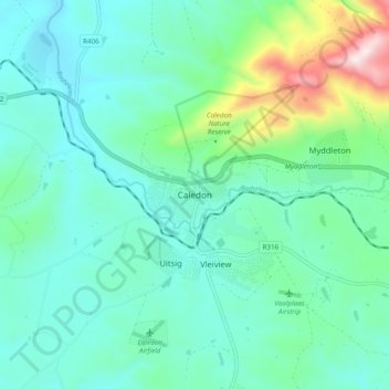
Name: Caledon topographic map, elevation, terrain.
Average elevation: 1,020 ft
Minimum elevation: 512 ft
Maximum elevation: 3,018 ft
Other topographic maps
Click on a map to view its topography, its elevation and its terrain.
Bot River
South Africa > Western Cape > Overberg District Municipality > Theewaterskloof Local Municipality
Average elevation: 1,004 ft
Salt River
South Africa > Western Cape > Overberg District Municipality > Theewaterskloof Local Municipality
Average elevation: 787 ft